Joliette
Joliette | |
|---|---|
| Ville de Joliette | |
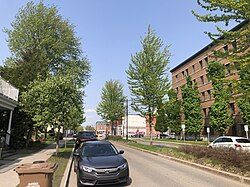
 boulevard Manseau | |
 Location within Joliette RCM. | |
| Coordinates: 46°01′N 73°27′W / 46.017°N 73.450°W[1] | |
| Country | |
| Province | |
| Region | Lanaudière |
| RCM | Joliette |
| Constituted | November 12, 1966 |
| Government | |
| • Mayor | Pierre-Luc Bellerose |
| • Federal riding | Joliette |
| • Prov. riding | Joliette |
| Area | |
• City | 23.60 km2 (9.11 sq mi) |
| • Land | 22.96 km2 (8.86 sq mi) |
| • Urban | 39.03 km2 (15.07 sq mi) |
| • Metro | 108.66 km2 (41.95 sq mi) |
| Population (2021)[3] | |
• City | 21,384 |
| • Density | 891.8/km2 (2,310/sq mi) |
| • Urban | 49,246 |
| • Urban density | 1,261.7/km2 (3,268/sq mi) |
| • Metro | 52,706 |
| • Metro density | 485.0/km2 (1,256/sq mi) |
| • Pop 2016-2021 | |
| • Dwellings | 10,285 |
| Demonym(s) | Joliettain, Joliettaine |
| Time zone | UTC−5 (EST) |
| • Summer (DST) | UTC−4 (EDT) |
| Postal code(s) | |
| Area code(s) | 450 and 579 |
| Highways | |
| Website | www |
Joliette is a city in southwest Quebec, Canada. It is approximately 50 kilometres (31 mi) northeast of Montreal, on the L'Assomption River and is the seat of the Regional County Municipality of Joliette. It is considered to be a part of the North Shore of Greater Montreal. The city is home to the Joliette Art Museum, whose works of art include paintings, sculptures, paper artwork and a large collection of art from the French Middle Ages.
Joliette has 3 Francophone high schools and 1 Anglophone high school, as well as the Joliette campus of the Cégep régional de Lanaudière.[4]
It was founded as L'Industrie by the businessman Barthélemy Joliette in 1823 and was incorporated as a city in 1863, when it changed its name to Joliette..
The city's economy is mainly in the manufacturing and service sectors. The largest gravel manufacturer in the area, Graybec, is located in Joliette and exploits a huge quarry just outside the city.
Joliette is the seat of the judicial district of Joliette.[5]
Demographics
In the 2021 Census of Population conducted by Statistics Canada, Joliette had a population of 21,384 living in 10,568 of its 11,153 total private dwellings, a change of 4.4% from its 2016 population of 20,484. With a land area of 22.96 km2 (8.86 sq mi), it had a population density of 931.4/km2 (2,412.2/sq mi) in 2021.[6]
7.1% of residents were visible minorities, 2.4% were Indigenous, and the remaining 90.5% were white/European. The largest visible minority groups were Black (3.1%), Latin American (1.7%) and Arab (1.3%).[7]
French was the mother tongue of 92.3% of residents. Other common first languages were Spanish (1.2%), English (1.1%), Arabic (0.8%) and Atikamekw (0.5%). 1.0% claimed both French and English as mother tongues, and 0.9% listed both French and a non-official language.
65.6% of residents were Christian, down from 85.4% in 2011.[8] 58.2% were Catholic, 4.7% were Christian n.o.s, 0.7% and were Protestants. All other Christian denominations and Christian-related traditions made up 1.9% of the population. 31.3% of the population were non-religious or secular, up from 11.8% in 2011. The only named non-Christians religions with a significant following in Joliette were Islam (2.4%) and Buddhism (0.3%). All other religions and spiritual traditions made up 0.5% of the population.
Government and infrastructure
Joliette is the seat of the judicial district of Joliette.[5]
Joliette Institution for Women, a prison of the Correctional Service of Canada, is in this town.
Economy
The city's economy is mainly in the manufacturing and service sectors. The largest gravel manufacturer in the area, Graybec, is located in Joliette and exploits a huge quarry just outside the city.
In the center of the city is Galeries Joliette, which has nearly 100 retailers as well as a 5-storey office building.[9]
Local institutions
Post-secondary:
- Cégep régional de Lanaudière à Joliette - Collège Constituent de Joliette
Commission scolaire des Samares operates Francophone public schools;
- École secondaire Thérèse-Martin
- École secondaire Barthélemy-Joliette
- École Primaire Les Mélèzes
- École Primaire Saint-Pierre (Marie-Charlotte)
Anglophone schools are operated by the Sir Wilfrid Laurier School Board:
- Joliette Elementary School in Saint-Charles-Borromée[10]
- Joliette High School[11]
Private schools:
- Académie Antoine-Manseau (francophone)
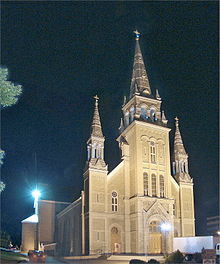
Diocese

Notable people
- A.J. Greer - ice hockey player
- Francine Racette - actress
- Charles Richard-Hamelin - concert pianist
- Dominique Ducharme - former head coach of the Montreal Canadiens
- Paul Tellier - businessman and public servant
- Marie-Hélène Turcotte - animated film director and artist
- Victor Desautels - actor, pianist, and physicist[12]
See also
References
- ^ "Banque de noms de lieux du Québec: Reference number 125035". toponymie.gouv.qc.ca (in French). Commission de toponymie du Québec.
- ^ a b "Joliette". Répertoire des municipalités (in French). Ministère des Affaires municipales, des Régions et de l'Occupation du territoire. Archived from the original on 2012-06-07. Retrieved 2011-11-08.
- ^ a b "Joliette census profile". 2021 Census data. Statistics Canada. 29 November 2017. Retrieved 2022-04-05.
- ^ http://www.swlauriersb.qc.ca/?page=schools/joliette-high
- ^ a b Territorial Division Act. Revised Statutes of Quebec D-11.
- ^ "Population and dwelling counts: Canada, provinces and territories, and census subdivisions (municipalities), Quebec". Statistics Canada. February 9, 2022. Retrieved August 29, 2022.
- ^ "Census Profile, 2021 - Joliette, Ville". Statistics Canada. 9 February 2022. Retrieved January 14, 2023.
- ^ "National Household Survey (NHS) Profile, 2011". Statistics Canada. 8 May 2013. Retrieved January 14, 2023.
- ^ "Galeries Joliette".
- ^ "JOLIETTE ELEMENTARY ZONE Archived 2017-09-17 at the Wayback Machine." Sir Wilfrid Laurier School Board. Retrieved on September 17, 2017.
- ^ "Joliette High School Zone Sec 1-5 Archived 2017-09-04 at the Wayback Machine." Sir Wilfrid Laurier School Board. Retrieved on September 5, 2017.
- ^ "Victor DESAUTELS Obituary (2015) - Dollard des Ormeaux, QC - The Gazette". Legacy.com. 26 March 2015.
External links
- Ville de Joliette
- Diocèse de Joliette
- "Diocese of Joliette". Catholic-Hierarchy.org. David M. Cheney.


