Rasra
Rasra
Chhoti Kaashi | |
|---|---|
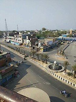
 Pyare Lal Chowk at Rasra | |
| Nickname: Nath Nagari | |
| Coordinates: 25°51′N 83°51′E / 25.85°N 83.85°E | |
| Country | |
| State | Uttar Pradesh |
| Division | Azamgarh |
| District | Ballia |
| Area | |
• Total | 19 km2 (7 sq mi) |
| Elevation | 70 m (230 ft) |
| Population (2019) | |
• Total | 29,263 |
| • Density | 1,500/km2 (4,000/sq mi) |
| Language | |
| • Official | Hindi |
| • Others | Bhojpuri, Urdu |
| Time zone | UTC+5:30 (IST) |
| PIN | 221712 |
| Area code | 05491 |
Rasra is a city and a municipal board in Ballia district in the Indian state of Uttar Pradesh. It is one among six tehsils that come under Ballia district, Rasra is also known as 'Chhoti Kashi' and 'Nath Nagri' due to the presence of Nath Baba mandir which is a well known religious spot. In past the production of sugar from rotten sugarcanes lead to the city being named 'Rasra' which is a portmanteau word made-up of two hindi words 'Ras' (रस) meaning juice and 'Sada/Sara' (सड़ा) meaning rotten. It has an important market for the nearby villages. Lounglatta is the famous sweet of Rasra. Dussehra is one of two very prominent festivals, here, alongside Chhath . Rasra has top schools of district. Rasra has second largest Durga Puja celebration in Uttar Pradesh after Ram Nagar, Varanasi. Rasra has a busy fish market, chicken market and mutton narket. It has also Sadar Bazaar, Station Road Market, Hospital Complex Market, Mission Road Market, Kali Maa ka chauraha. This place is known for all religious cultures, and has many temples, churches and mosques. [citation needed]
Geography
[edit]Rasra is 34 km far from Ballia and 42 km from Mau. Rasra is located at 25°51′N 83°51′E / 25.85°N 83.85°E.[1] It has an average elevation of 55 metres (180 ft).
Tourism place and Temple
[edit]- Sri Nath Ji Math Nagpur
- Sri Nath Ji Math Nagpura
- Sri Nath Ji Math Rasra
- Historical Ramleela Maidan Rasra
- Sri Nath Ji Math Maharajpur
- Sri Nath Ji Math Kanso-Patna
- Sri Kali Ji Temple Rasra
- Sri Khaki Baba Temple Khanwar
- Temple Bulaki das ki mathiya
- Sri Brahm Ji Temple Bramsthan
- Sri Lakhneswar Dham (Mundera)
Demographics
[edit]As of 2019[update] India census,[2] Rasra had a population of 29,263.
References
[edit]- ^ Falling Rain Genomics, Inc - Rasra
- ^ "Census of India 2001: Data from the 2001 Census, including cities, villages and towns (Provisional)". Census Commission of India. Archived from the original on 16 June 2004. Retrieved 1 November 2008.

