Chenzhou
Chenzhou
郴州市 | |
|---|---|
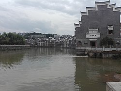
 Chen River and the residential on the river bank in Chenzhou City | |
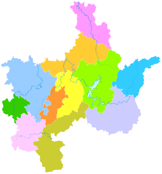
 Chenzhou's administrative area in Hunan | |
| Coordinates (Chenzhou municipal government): 25°46′12″N 113°00′58″E / 25.770°N 113.016°E | |
| Country | People's Republic of China |
| Province | Hunan |
| Municipal seat | Beihu District |
| Area | |
| 19,317 km2 (7,458 sq mi) | |
| • Urban (2017)[1] | 580.00 km2 (223.94 sq mi) |
| Population (2010 census) | |
| 4,581,778 | |
| • Density | 240/km2 (610/sq mi) |
| • Urban (2020)[1] | 960,000 |
| GDP[2] | |
| • Prefecture-level city | CN¥ 298.1 billion US$ 44.2 billion |
| • Per capita | CN¥ 64,279 US$ 9,558 |
| Time zone | UTC+8 (China Standard) |
| Postal code | 423000 |
| Area code | 0735 |
| ISO 3166 code | CN-HN-10 |
| License plate prefixes | 湘L |
| Website | en |
Chenzhou (Chinese: 郴州; pinyin: Chēnzhōu) is a prefecture-level city located in the south of Hunan province, China, bordering the provinces of Jiangxi to the east and Guangdong to the south. Its administrative area covers 19,317 square kilometres (7,458 sq mi), 9.2% of the provincial area, and its total population reached 4,581,779 in the 2010 census, 26% of them living in urban areas, 74% of them live in rural areas.[3]
History
Chenzhou is a historical city dating back from the Qin dynasty. The area was historically named Guiyang (simplified Chinese: 桂阳; traditional Chinese: 桂陽; pinyin: Guìyáng) Commandery before being renamed to the current name in the year 735 during the Tang dynasty. The Chinese character 郴, meaning "City in the Forest", uniquely refers to only the area. Known to be popular among the literacy circle of the Tang courts, poets such as Wang Changling, Du Fu, Han Yu, Liu Yuxi and Qin Guan have visited and wrote poems to the natural beauty of the area.
According to unsourced claims from Jung Chang and Jon Halliday in their book Mao: The Unknown Story, Chenzhou, along with neighboring Leiyang city was razed in 1928 by troops (Chinese Red Army) under the command of Zhu De, who was following directives which originated in Moscow and passed on by higher officials of the Chinese Communist Party. The strategy was to leave large numbers of peasants from the cities with no option but to join communist uprisings. [citation needed]
Chenzhou was the site of a large investigation when its municipal government and party committee, led by Secretary Li Dalun, was charged on multiple counts of corruption in June 2006. [4]
Geography
Chenzhou is situated at the juncture of Hunan and Guangdong provinces at the foot of small Qitian Mountains of the Nanling Mountain Range. Places of interest, natural scenic spots, ancient relics and buildings make for over 100 tourism spots in the city. The major ones are the Suxian Hill, the Wanhuayan, the Dongjiang Lake, and the Wugai Mountain Hunting Field.[5]
Climate
Chenzhou has a humid subtropical climate (Köppen climate classification: Cfa), with four distinct seasons. Spring is subject to heavy rainfall, while the summers are long, hot, and humid with lesser rainfall, and autumn is comfortable and rather dry. Winter is rather brief, but cold snaps occur with temperatures occasionally dropping below freezing, and while not heavy, rain can be frequent.[5]
| Climate data for Chenzhou (1991–2015 normals, extremes 1971–2010) | |||||||||||||
|---|---|---|---|---|---|---|---|---|---|---|---|---|---|
| Month | Jan | Feb | Mar | Apr | May | Jun | Jul | Aug | Sep | Oct | Nov | Dec | Year |
| Record high °C (°F) | 27.0 (80.6) |
32.0 (89.6) |
33.7 (92.7) |
35.6 (96.1) |
36.2 (97.2) |
38.0 (100.4) |
40.3 (104.5) |
40.5 (104.9) |
38.6 (101.5) |
36.4 (97.5) |
33.5 (92.3) |
27.4 (81.3) |
40.5 (104.9) |
| Mean daily maximum °C (°F) | 10.2 (50.4) |
13.4 (56.1) |
17.3 (63.1) |
23.9 (75.0) |
28.0 (82.4) |
31.2 (88.2) |
34.2 (93.6) |
33.0 (91.4) |
29.2 (84.6) |
24.6 (76.3) |
19.0 (66.2) |
13.1 (55.6) |
23.1 (73.6) |
| Daily mean °C (°F) | 6.6 (43.9) |
9.3 (48.7) |
13.1 (55.6) |
19.2 (66.6) |
23.6 (74.5) |
27.0 (80.6) |
29.6 (85.3) |
28.3 (82.9) |
24.7 (76.5) |
19.8 (67.6) |
14.2 (57.6) |
8.6 (47.5) |
18.7 (65.6) |
| Mean daily minimum °C (°F) | 4.1 (39.4) |
6.6 (43.9) |
10.1 (50.2) |
15.9 (60.6) |
20.2 (68.4) |
23.9 (75.0) |
26.1 (79.0) |
25.0 (77.0) |
21.4 (70.5) |
16.3 (61.3) |
10.8 (51.4) |
5.5 (41.9) |
15.5 (59.9) |
| Record low °C (°F) | −5.9 (21.4) |
−6.8 (19.8) |
−1.9 (28.6) |
2.9 (37.2) |
10.0 (50.0) |
13.4 (56.1) |
18.6 (65.5) |
18.3 (64.9) |
13.2 (55.8) |
2.2 (36.0) |
−2.8 (27.0) |
−6.3 (20.7) |
−6.8 (19.8) |
| Average precipitation mm (inches) | 80.0 (3.15) |
97.8 (3.85) |
156.1 (6.15) |
169.3 (6.67) |
188.2 (7.41) |
195.7 (7.70) |
126.3 (4.97) |
191.3 (7.53) |
86.8 (3.42) |
72.0 (2.83) |
78.4 (3.09) |
68.2 (2.69) |
1,510.1 (59.46) |
| Average precipitation days (≥ 0.1 mm) | 16.4 | 16.1 | 19.4 | 16.5 | 17.4 | 15.8 | 10.3 | 14.6 | 11.7 | 10.7 | 11.7 | 12.0 | 172.6 |
| Average snowy days | 3.5 | 1.7 | 0.3 | 0 | 0 | 0 | 0 | 0 | 0 | 0 | 0 | 0.8 | 6.3 |
| Average relative humidity (%) | 80 | 80 | 80 | 76 | 75 | 74 | 66 | 72 | 76 | 75 | 76 | 76 | 76 |
| Mean monthly sunshine hours | 53.5 | 53.4 | 59.5 | 91.2 | 111.9 | 127.7 | 219.0 | 162.3 | 121.1 | 118.0 | 100.0 | 84.4 | 1,302 |
| Percent possible sunshine | 16 | 17 | 16 | 24 | 27 | 31 | 52 | 40 | 33 | 33 | 31 | 26 | 29 |
| Source 1: China Meteorological Administration[6][7] | |||||||||||||
| Source 2: Weather China[8] | |||||||||||||
Administrative divisions

- Beihu District (北湖区), 815 km2 (315 sq mi). Population: 300,000 (2003).
- Suxian District (苏仙区), 1,342 km2 (518 sq mi). Population: 249,900
- Zixing City (资兴市) 2,716 km2 (1,049 sq mi). Population: 360,000
- Guiyang County (桂阳县), 2,954 km2 (1,141 sq mi). Population: 790,000
- Yongxing County (永兴县), 1,979 km2 (764 sq mi). Population: 630,000
- Yizhang County (宜章县), 2,086 km2 (805 sq mi). Population: 560,000
- Jiahe County (嘉禾县), 696 km2 (269 sq mi). Population: 340,000
- Linwu County (临武县), 1,375 km2 (531 sq mi). Population: 310,000
- Rucheng County (汝城县), 2,424 km2 (936 sq mi). Population: 360,000
- Guidong County (桂东县), 1,453 km2 (561 sq mi). Population: 170,000
- Anren County (安仁县), 1,461 km2 (564 sq mi). Population: 390,000
| Map |
|---|
Economy
Major deposits of tungsten, bismuth and molybdenum make Chenzhou a production base for non-ferrous metals.
Colleges and universities
- Xiangnan University(湘南学院)
- Chenzhou Vocational Technical College
Notable people
- Duan Yixuan, a singer and actress
- Long Yang, a hostess in CCTV
- Ouyang Jingling, a paralympic athlete
- Xue Yiwei, Chinese writer living in Montreal[9]
- Li Xingxue (李星学), Chinese botanist and member of Chinese Academy of Sciences
Government
The current CPC Party Secretary of Chenzhou is Yi Pengfei and the current Mayor is Liu Zhiren.
Tourism
The areas of interest in Chenzhou include: Wanhua Rock (万华岩), Wugai Mountain Hunting Field, Suxian Hill and Dongjiang Lake. The city is served by Chenzhou Beihu Airport.
References
- ^ a b Ministry of Housing and Urban-Rural Development, ed. (2019). China Urban Construction Statistical Yearbook 2017. Beijing: China Statistics Press. p. 68. Archived from the original on 18 June 2019. Retrieved 11 January 2020.
- ^ "2022年湖南省各市州地区生产总值(三季度".
- ^ (in Chinese) Demographics of Chenzhou Archived May 11, 2008, at the Wayback Machine, Official website of Chenzhou Government, August 28, 2007.
- ^ "zh:湖南郴州市委书记落马背后:治下发生连串丑闻" [Behind the fall of Hunan's Chenzhou city party secretary: a string of scandals under his rule]. THE STATE COUNCIL THE PEOPLE'S REPUBLIC OF CHINA (in Chinese). 2006-06-09. Retrieved 2024-06-07.
- ^ a b "zh:郴州自然地理" [Physical Geography of Chenzhou]. The People's Government of ChenZhou City (in Chinese). 2013-06-15. Retrieved 2024-06-06.
- ^ 中国气象数据网 – WeatherBk Data (in Simplified Chinese). China Meteorological Administration. Retrieved 11 June 2023.
- ^ "Experience Template" 中国气象数据网 (in Simplified Chinese). China Meteorological Administration. Retrieved 28 May 2023.
- ^ 郴州 - 气象数据 -中国天气网 (in Chinese). Weather China. Retrieved 21 November 2022.
- ^ "The Fate of a Novel Amid China's Reform". University of California Los Angeles. Retrieved 2022-07-29.
External links
- Chenzhou News Website, run by Chenzhou Government
- Official website of Chenzhou Government


