Štěnovice
Štěnovice | |
|---|---|
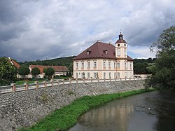
 Úhlava River and castle in Štěnovice | |
| Coordinates: 49°40′14″N 13°24′0″E / 49.67056°N 13.40000°E | |
| Country | |
| Region | Plzeň |
| District | Plzeň-South |
| First mentioned | 1327 |
| Area | |
• Total | 7.67 km2 (2.96 sq mi) |
| Elevation | 330 m (1,080 ft) |
| Population (2024-01-01)[1] | |
• Total | 2,329 |
| • Density | 300/km2 (790/sq mi) |
| Time zone | UTC+1 (CET) |
| • Summer (DST) | UTC+2 (CEST) |
| Postal code | 332 09 |
| Website | www |
Štěnovice is a municipality and village in Plzeň-South District in the Plzeň Region of the Czech Republic. It has about 2,300 inhabitants.
Etymology
The name is derived from the personal name Štěňa, meaning "the village of Štěňa's people".[2]
Geography
Štěnovice is located about 6 kilometres (4 mi) south of Plzeň. It lies in the Švihov Highlands. The highest point is a nameless hill at 472 m (1,549 ft) above sea level. The municipality is situated on the right bank of the Úhlava River.
History
The first written mention of Štěnovice is from 1327. The village was owned by various lower noble families. For a long time Štěnovice was owned by the Kadovský family (1460s–1554) and Henigars of Žeberk (1601–1697). Among the most important owners was Countess Terezie Pöttingová, who founded here the Trinitarian monastery with a church in 1747–1753.[3]
Demographics
|
|
| ||||||||||||||||||||||||||||||||||||||||||||||||||||||
| Source: Censuses[4][5] | ||||||||||||||||||||||||||||||||||||||||||||||||||||||||
Transport
The D5 motorway from Prague to Plzeň (part of the European route E50) runs along the northern municipal border.
Sights

The main landmark of the centre of Štěnovice is the Trinitarian monastery with the Church of Saint Procopius. They were built in the Baroque style in 1747–1753, by the reconstruction of an early Baroque granary. The parish church still serves its purpose. The former monastery is partly used as an apartment and partly unused.[6]
The Štěnovice Castle is located on the opposite bank of the Úhlava River from the rest of the village. It was built in the Baroque style in 1723. Next to the castle is a small park with quality Baroque sculptural decoration. Today the castle is privately used and is occasionally used for social purposes.[7]
References
- ^ "Population of Municipalities – 1 January 2024". Czech Statistical Office. 2024-05-17.
- ^ Profous, Antonín (1957). Místní jména v Čechách IV: S–Ž (in Czech). p. 296.
- ^ "Historie" (in Czech). Obec Štěnovice. Retrieved 2024-03-13.
- ^ "Historický lexikon obcí České republiky 1869–2011 – Okres Plzeň-jih" (in Czech). Czech Statistical Office. 2015-12-21. pp. 13–14.
- ^ "Population Census 2021: Population by sex". Public Database. Czech Statistical Office. 2021-03-27.
- ^ "Klášter trinitářů s kostelem sv. Prokopa" (in Czech). National Heritage Institute. Retrieved 2024-03-13.
- ^ "Zámek" (in Czech). National Heritage Institute. Retrieved 2024-03-13.


