Talk:Hoher Göll
| This article is rated Start-class on Wikipedia's content assessment scale. It is of interest to the following WikiProjects: | ||||||||||||||||||||||||||||||||||
| ||||||||||||||||||||||||||||||||||
Featured picture scheduled for POTD
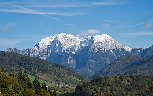
[edit]Hello! This is to let editors know that File:Göll (Westseite).jpg, a featured picture used in this article, has been selected as the English Wikipedia's picture of the day (POTD) for August 20, 2024. A preview of the POTD is displayed below and can be edited at Template:POTD/2024-08-20. For the greater benefit of readers, any potential improvements or maintenance that could benefit the quality of this article should be done before its scheduled appearance on the Main Page. If you have any concerns, please place a message at Wikipedia talk:Picture of the day. Thank you! — Amakuru (talk) 12:55, 10 August 2024 (UTC)

|
|
The Hoher Göll is a mountain in the Berchtesgaden Alps. At 2,522 metres (8,274 feet), it is the highest peak of the Göll massif, which straddles the border between the German state of Bavaria and the Austrian state of Salzburg. This photograph shows the Hoher Göll (left) and the Hohes Brett (right) from the west. Photograph credit: Jörg Braukmamm
Recently featured:
|
- Start-Class Mountain articles
- Low-importance Mountain articles
- Start-Class Mountains of the Alps articles
- Mid-importance Mountains of the Alps articles
- All WikiProject Mountains pages
- Start-Class Germany articles
- Low-importance Germany articles
- WikiProject Germany articles
- Start-Class Austria articles
- Low-importance Austria articles
- All WikiProject Austria pages

