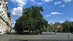
Čelákovice
Čelákovice | |
|---|---|
 5. května Square | |
| Coordinates: 50°9′38″N 14°45′0″E / 50.16056°N 14.75000°E | |
| Country | |
| Region | Central Bohemian |
| District | Prague-East |
| First mentioned | 1290 |
| Government | |
| • Mayor | Josef Pátek (ODS) |
| Area | |
• Total | 15.88 km2 (6.13 sq mi) |
| Elevation | 184 m (604 ft) |
| Population (2024-01-01)[1] | |
• Total | 12,463 |
| • Density | 780/km2 (2,000/sq mi) |
| Time zone | UTC+1 (CET) |
| • Summer (DST) | UTC+2 (CEST) |
| Postal code | 250 88 |
| Website | www |
Čelákovice (Czech pronunciation: [ˈtʃɛlaːkovɪtsɛ]) is a town in Prague-East District in the Central Bohemian Region of the Czech Republic. It has about 12,000 inhabitants.
Administrative parts
[edit]The villages of Císařská Kuchyně, Sedlčánky and Záluží are administrative parts of Čelákovice.
Geography
[edit]Čelákovice is located about 15 kilometres (9 mi) east of Prague. It lies in the Central Elbe Table, in the Polabí lowlands. The town is situated on the left bank of the Elbe River.
History
[edit]The site of the town has been inhabited since the Stone Age. During the 9th century, an early Slavic settlement was established. The first written mention of Čelákovice is from 1290. The inhabitants subsisted on fishing and agriculture, and from the mid-19th century also on the production of baskets.[2]
Demographics
[edit]
|
|
| ||||||||||||||||||||||||||||||||||||||||||||||||||||||
| Source: Censuses[3][4] | ||||||||||||||||||||||||||||||||||||||||||||||||||||||||
Economy
[edit]The engineering factory known as TOS (Továrna obráběcích strojů) was founded in 1910. It remains the largest industrial plant in the town.
Transport
[edit]Čelákovice is located on the railway lines Prague–Kolín and Neratovice–Čelákovice.[5]
Sights
[edit]
Around 1300, a stone fortress was built here. The fortress, reconstructed in 1973–1982 in the Gothic–Renaissance style, serves today as the town museum.[2]
The Church of the Assumption of the Virgin Mary was originally a Romanesque structure, rebuilt in the Renaissance style in the 16th century and in the Baroque style in 1708–1712.[2]
The landmark of the town square is the town hall. It was built in the neo-Baroque style in 1911.[6]
Notable people
[edit]- Alois Vašátko (1908–1942), World War II wing commander
- František Čáp (1913–1972), Czech-Yugoslav film director and screenwriter
- Eduard Petiška (1924–1987), writer of children books
- Pavel Tykač (born 1964), entrepreneur
International relations
[edit]Čelákovice has no twin towns. The town has cooperation agreement with Chengdu, China.[7]
Gallery
[edit]-
Town hall
-
Sedláčkova street
-
Former fortress, now the Town Museum
-
Palackého street
References
[edit]- ^ "Population of Municipalities – 1 January 2024". Czech Statistical Office. 2024-05-17.
- ^ a b c "Historie" (in Czech). Město Čelákovice. Retrieved 2022-05-04.
- ^ "Historický lexikon obcí České republiky 1869–2011" (in Czech). Czech Statistical Office. 2015-12-21.
- ^ "Population Census 2021: Population by sex". Public Database. Czech Statistical Office. 2021-03-27.
- ^ "Detail stanice Čelákovice" (in Czech). České dráhy. Retrieved 2024-05-19.
- ^ "Novobarokní radnice v Čelákovicích" (in Czech). CzechTourism. Retrieved 2023-03-21.
- ^ "Partnerství" (in Czech). Město Čelákovice. Retrieved 2021-06-19.
External links
[edit]


