Mian Channu
Mian Channu
مياں چنوں | |
|---|---|
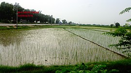
 Rice fields in Mian Channu | |
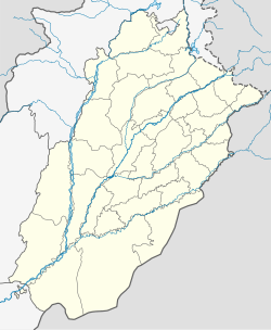
| Coordinates: 30°16′N 72°13′E / 30.27°N 72.22°E | |
| Country | |
| Province | Punjab |
| District | Khanewal |
| Population | |
• City | 140,112 |
| Time zone | UTC+5 (PST) |
Mian Channu[a] (Urdu / Template:Lang-pa), is the capital city of Mian Channu Tehsil in Khanewal District, Punjab province of Pakistan.[2]
Etymology
The city was named after a Sufi saint, Baba Mian Channu, who had lived there at one point. After his death, he was buried there. There is an urban legend about the name; it is believed that during the British rule, administration attempted to change the name of the city. They painted all boards with the new name. However, an unknown vandal changed the boards back to the original name. They tried repeatedly in vain, and since then, the name of the city remained 'Mian Channu'.
Mian Channu has many services and areas for its inhabitants, as well as tourists.
History
Mian Channu was part of wide Multan region after the Islamic conquest of Punjab region in the 8th century CE by Arab Umayyads. Mian Channu was considered a village, and by 1938, it was considered a town of Multan region. Its limits were last extended in the year 1950. Since then, no extension has been made, and the development of the town from 1947 to 1961 remained slow. A municipal council was established in 1975, as it had grown into small urban centre by that time. After that, the town began developing, and major growth has been taking place, from 1972 to 1984. The trend of growth in this period has largely been along G.T Road, and in the northern direction.
It has been the headquarters of the Mian Channu Tehsil of Khanewal District since 1985,[3] and is administratively subdivided into three Union councils.[1]
For more than a century, Mian Channu was part of Multan District. With the raising of status of Mian Channu to a tehsil headquarters, and the creation of Khanewal District on 1 July 1985, Mian Channu Tehsil became a part of Khanewal District.[3]
An accidentally fired BrahMos missile from India landed in Mian Channu in 2022, resulting in the 2022 India–Pakistan missile incident.
Demographics
Mian Channu has approximately 90,130 residents per the 2017 census,[1] and is located on the Grand Trunk Road (250 km South West of Lahore, and 1,050 km northeast of Karachi), and KLP (Karachi, Lahore, Peshawar) railway line.
- Faisal Town, residential area
Economy
The city is one of the major contributor to agricultural production. Cotton, wheat, and mangoes are the major agricultural products. Major crops of the town are wheat, grain, peas, barley are the important crops of Rabi season, while Kharif crops are cotton, sugarcane, jawar, bajra, oil seeds which are shipped by rail and road to other parts of the country.[2]
The city is also known for their local specialty, Khushi Barfi, which is a kind of condensed milk.
Notable people
- Ghulam Haider Wyne - Pakistani Politician (Former Chief Minister Punjab)
- Arshad Nadeem - Olympic Gold Medalist Athlete (Javelin thrower)
- Maulana Tariq Jameel - Pakistani Islamic television preacher, scholar.[4]
- Iftikhar Thakur - Pakistani actor and stand up comedian.
- Pir Muhammad Aslam Bodla - Pakistani Politician
- Pir Zahoor Hussain Qureshi - Pakistani Politician
- Rana Babar Hussain - Pakistani Politician
- Begum Majeeda Wyne - Pakistani Politician
- Ayub Ommaya - Pakistani-American neurosurgeon (NIH USA)
- Humza Yousaf - former First Minister of Scotland and Leader of the Scottish National Party (SNP)
References
- ^ Alternative spelled as Mian Chunnun; Punjabi pronunciation: [ˈmiːjä̃ː t͡ʃɐ̃nˈnũː], Urdu pronunciation: [ˈmɪjɑ̃ː t͡ʃʊ̃nˈnũː]
- ^ a b c "Tehsils & Unions in the District of Khanewal". National Reconstruction Bureau, Government of Pakistan website. Archived from the original on 7 August 2011. Retrieved 16 May 2022.
- ^ a b "Khanewal District includes Mian Channu". Punjab Portal, Government of the Punjab website. 22 August 2012. Archived from the original on 12 August 2013. Retrieved 16 May 2022.
- ^ a b "Khanewal History includes Mian Channu". Government of Khanewal website. Archived from the original on 21 May 2009. Retrieved 16 May 2022.
- ^ "Maulana Tariq Jameel". The Muslim 500 website. Retrieved 16 May 2022.
30°27′N 72°22′E / 30.450°N 72.367°E


