Giheung District
Appearance
Giheung District
기흥구 | |
|---|---|
| Korean transcription(s) | |
| • Hanja | 器興區 |
| • Revised Romanization | Giheung-gu |
| • McCune–Reischauer | Kihŭng-gu |
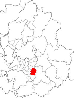
 Map of Gyeonggi highlighting Giheung District. | |
| Country | South Korea |
| Region | Sudogwon (Gijeon) |
| Province | Gyeonggi |
| City | Yongin |
| Area | |
• Total | 81.67 km2 (31.53 sq mi) |
| Population (2022) | |
• Total | 439,877 |
| • Density | 5,384.17/km2 (13,944.9/sq mi) |
| • Dialect | Seoul |
| Website | Giheung District Office |
Giheung District (Korean: 기흥구; RR: Giheung-gu) is a gu (district) in Yongin, South Korea. It has 10 dong (neighborhoods). Its area is 81.67 km2 and it has 439.877 inhabitants (in 2022). Giheung District was formed in 2005. It was formed with other gu in Yongin in 2005.
Administrative divisions
[edit]Giheung District is divided into the following "dong"s.
- Giheung-dong (divided in turn into Gomae-dong and Gongse-dong)
- Sanggal-dong (divided in turn into Sanggal-dong, Bora-dong and Jigok-dong)
- Singal-dong (divided in turn into Singal-dong, Hagal-dong and Yeongdeok-dong)
- Guseong-dong (divided in turn into Eonnam-dong and Cheongdeok-dong)
- Dongbaek-dong (divided in turn into Dongbaek-dong and Jung-dong)
- Seonong-dong (combination of Seocheon-dong and Nongseo-dong)
- Gugal-dong
- Mabuk-dong
- Bojeong-dong
- Sangha-dong
List of gu in Yongin
[edit]Attractions
[edit]- Hill 151 in Bora-dong, There was a battle between Turkish Brigade and Chinese People's Volunteer Army during Korean War.
Gallery
[edit]-
Gugal-dong
-
Bojeong-dong
References
[edit]
37°16′49″N 127°06′53″E / 37.280406°N 127.114659°E


