Livartzi
Appearance
Livartzi
Λιβάρτζι | |
|---|---|
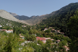
 Livartzi, between the mountains | |
| Coordinates: 37°56′N 21°54′E / 37.933°N 21.900°E | |
| Country | Greece |
| Administrative region | West Greece |
| Regional unit | Achaea |
| Municipality | Kalavryta |
| Municipal unit | Aroania |
| Population (2021)[1] | |
• Community | 150 |
| Time zone | UTC+2 (EET) |
| • Summer (DST) | UTC+3 (EEST) |
Livartzi (Greek: Λιβάρτζι) is a mountain village and a community in the municipal unit of Aroania, Achaea, Greece. The community includes the villages Livadi and Livartzino. Livartzi is situated at 850 m above sea level, in the southeastern foothills of Mount Erymanthos. It is 4 km southwest of Lechouri, 6 km north of Psofida and 21 km southwest of Kalavryta. It is not known when Livartzi was founded, but it existed before the Ottoman rule. In the 19th century, refugees from Mystras settled the area and the population rose to around 3,000 people.
Population
[edit]| Year | Population village | Population community |
|---|---|---|
| 19th century | around 3,000 | - |
| 1991 | 289 | - |
| 2001 | 303 | 422 |
| 2011 | 164 | 211 |
| 2021 | 118 | 150 |
People
[edit]- Andreas Papagiannakopoulos (1845–1911), politician
See also
[edit]References
[edit]- ^ "Αποτελέσματα Απογραφής Πληθυσμού - Κατοικιών 2021, Μόνιμος Πληθυσμός κατά οικισμό" [Results of the 2021 Population - Housing Census, Permanent population by settlement] (in Greek). Hellenic Statistical Authority. 29 March 2024.

