Jump to content

Kałęga

Coordinates: 53°21′24.56″N 14°50′28.19″E / 53.3568222°N 14.8411639°E / 53.3568222; 14.8411639
From Wikipedia, the free encyclopedia

This is the current revision of this page, as edited by Monkbot (talk | contribs) at 23:51, 30 October 2024 (Task 20: replace {lang-??} templates with {langx|??} ‹See Tfd› (Replaced 1);). The present address (URL) is a permanent link to this version.

(diff) ← Previous revision | Latest revision (diff) | Newer revision → (diff)
Kałęga
Settlement
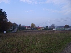
Skyline from Motaniec
Kałęga is located in Poland
Kałęga
Kałęga
Coordinates: 53°21′24.56″N 14°50′28.19″E / 53.3568222°N 14.8411639°E / 53.3568222; 14.8411639
Country Poland
VoivodeshipWest Pomeranian
CountyStargard
GminaKobylanka
Population
22

Kałęga [kaˈwɛnɡa] (German: Kähling) is a settlement in the administrative district of Gmina Kobylanka, within Stargard County, West Pomeranian Voivodeship, in northwestern Poland.[1]

For the history of the region, see History of Pomerania.

The settlement has a population of 22.

References

[edit]
  1. ^ "Central Statistical Office (GUS) - TERYT (National Register of Territorial Land Apportionment Journal)" (in Polish). 2008-06-01.