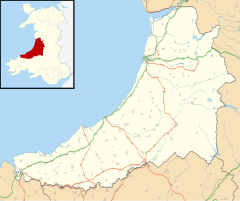
Ysbyty Ystwyth
Appearance
| Ysbyty Ystwyth | |
|---|---|
 This is the original parish church of Ystbyty Ystwyth. | |
Location within Ceredigion | |
| Population | 409 (2011)[1] |
| OS grid reference | SN7371 |
| • Cardiff | 90 mi (140 km)SE |
| Principal area | |
| Preserved county | |
| Country | Wales |
| Sovereign state | United Kingdom |
| Post town | YSTRAD MEURIG |
| Postcode district | SY25 |
| Dialling code | 01974 |
| Police | Dyfed-Powys |
| Fire | Mid and West Wales |
| Ambulance | Welsh |
| UK Parliament | |
| Senedd Cymru – Welsh Parliament | |
Ysbyty Ystwyth (Welsh pronunciation: [əsˈbəti ˈəstʊi̯θ]) is a small village and community in Ceredigion, Wales, 11 mi (18 km) southeast of Aberystwyth. Its church and the parish of the same name were the property of the Order of the Knights of the Hospital of St John of Jerusalem, hence the 'Ysbyty' in the title (Welsh for "hospital"), which never was (despite local belief) a hospice for travellers to Strata Florida.[2] The community includes the hamlets Logau-Las and Pont-rhyd-y-groes. The area is situated in the Desert of Wales and is wild country. The peak of Llan Ddu Fawr is located in the area and the lakes Llyn Fyrddon Fawr and Fach.
Notes
[edit]- ^ "Community population 2011". Retrieved 12 May 2015.
- ^ Ceredigion, A Wealth of History
External links
[edit]https://getoutside.ordnancesurvey.co.uk/local/llyn-fyrddon-fawr-ceredigion-sir-ceredigion
References
[edit]- Morgan, Gerald (2005). Ceredigion : a wealth of history. Llandysul: Gwasg Gomer. ISBN 978-1-84323-501-9. OCLC 61176203. Also published in paperback as ISBN 978-1-84323-580-4
- Lloyd, John Edward, Sir. (1911). A History of Wales from the Earliest Times to the Edwardian Conquest. Vol. 2. London; New York [etc.]: Longmans, Green, and co. LCCN 11009062. OCLC 643170.
{{cite book}}: CS1 maint: location (link) CS1 maint: multiple names: authors list (link)


