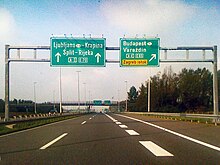
Ivanja Reka interchange
| Ivanja Reka interchange | |
|---|---|
| Croatian: Čvor Ivanja Reka | |
 Ivanja Reka interchange, approach along the westbound A3 | |
 | |
| Location | |
| Ivanja Reka, Zagreb, Croatia | |
| Coordinates | 45°48′00″N 16°07′52″E / 45.799965°N 16.131191°E |
| Roads at junction | |
| Construction | |
| Type | Cloverleaf interchange |
The Ivanja Reka interchange (Croatian: Čvor Ivanja Reka) is a cloverleaf interchange east of Zagreb, Croatia. The interchange represents the southern terminus of the A4 motorway and it connects the A4 route to the A3 motorway representing major a link in the Croatian motorway system.[1] The interchange is a part of Pan-European corridors Vb and X.[2] It also represents a junction of European routes E65, E70 and E71.[3]
The interchange was completed at junction of the Slavonska Avenue—four lane road providing access to Zagreb, present-day A3 motorway section to Lipovljani, built in 1980, and a 22.15-kilometre (13.76 mi) section between the Lučko and Ivanja Reka interchanges, a section of the Zagreb bypass opened in 1981. It was named after the nearby village of Ivanja Reka. The interchange originally also included a four-lane road, later upgraded and renamed as A4 motorway connecting Varaždin.[4][5]
See also
[edit]References
[edit]- ^ "Pravilnik o označavanju autocesta, njihove stacionaže, brojeva izlaza i prometnih čvorišta te naziva izlaza, prometnih čvorišta i odmorišta" [Regulation on motorway markings, chainage, interchange/exit/rest area numbers and names]. Narodne novine (in Croatian). May 6, 2003. Retrieved September 6, 2010.
- ^ "Transport : launch of the Italy-Turkey pan-European Corridor through Albania, Bulgaria, Former Yugoslav Republic of Macedonia and Greece". European Union. September 9, 2002. Retrieved September 6, 2010.[permanent dead link]
- ^ "European Agreement on Main International Traffic Arteries" (PDF). United Nations Economic Commission for Europe. March 13, 2008. Retrieved September 6, 2010.
- ^ "Gradnja autocesta na području Slavonije" [Construction of motorways in Slavonia] (PDF). Građevinar (in Croatian). September 7, 2006. Archived from the original (PDF) on July 18, 2011. Retrieved October 2, 2010.
- ^ Crnjak, Mario; Puž, Goran (November 2007). Kapitalna prometna infrastruktura [Capital transport infrastructure] (PDF). Hrvatske autoceste. pp. 18–20. ISBN 978-953-7491-02-2. Archived from the original (PDF) on October 4, 2011. Retrieved October 11, 2010.
