Chrzelice
Appearance
Chrzelice | |
|---|---|
Village | |
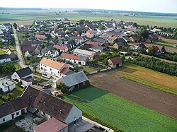
 Aerial view of Chrzelice | |
| Coordinates: 50°28′N 17°44′E / 50.467°N 17.733°E | |
| Country | |
| Voivodeship | Opole |
| County | Prudnik |
| Gmina | Biała |
| Population | 654 |
| Time zone | UTC+1 (CET) |
| • Summer (DST) | UTC+2 (CEST) |
| Vehicle registration | ORL |
| Website | http://chrzelice.pl/ |
Chrzelice ([xʂɛˈlʲit͡sɛ]) is a village in the administrative district of Gmina Biała, within Prudnik County, Opole Voivodeship, in southern Poland.[1] It lies approximately 9 kilometres (6 mi) north-east of Biała, 20 km (12 mi) north-east of Prudnik, and 27 km (17 mi) south-west of the regional capital Opole. Historically located in Upper Silesia, in the Prudnik Land.
History
[edit]The village was founded in the later half of the 13th century.[2]
In the Upper Silesia plebiscite on the 20th march 1921, the majority of villagers (777) voted to stay with Germany while only 39 voted for Poland.
During World War II, the Germans operated the E31 forced labour subcamp of the Stalag VIII-B/344 prisoner-of-war camp for Allied POWs in the village.[3]
References
[edit]- ^ "Central Statistical Office (GUS) - TERYT (National Register of Territorial Land Apportionment Journal)" (in Polish). 2008-06-01.
- ^ "Chrzelice - Urząd Miejski w Białej". biala.gmina.pl. Retrieved 2024-10-15.
- ^ "Working Parties". Lamsdorf.com. Archived from the original on 29 October 2020. Retrieved 5 November 2022.


