Bright, Victoria
unreferenced|date=January 2007}}
| Bright Victoria | |||||||||
|---|---|---|---|---|---|---|---|---|---|
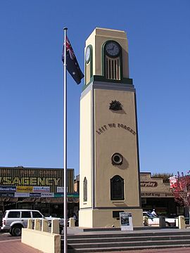
 War memorial in centre of Bright | |||||||||
| Population | 2,081 (2001 census) | ||||||||
| Postcode(s) | 3741 | ||||||||
| Elevation | 319 m (1,047 ft) | ||||||||
| Location |
| ||||||||
| LGA(s) | Alpine Shire | ||||||||
| State electorate(s) | Benalla | ||||||||
| Federal division(s) | Indi | ||||||||
| |||||||||
Bright (postcode: 3741, 36°43′S 146°57′E / 36.717°S 146.950°E) is a town in Victoria, Australia and stands 304 metres above Sea Level. At the 2001 census, Bright had a population of 2,081.[1] It is in the Alpine Shire local government area.
History
Hamilton Hume and William Hovell explored the area in 1824, naming the Ovens River.
The town was first known as Morse's Creek after F.H. Morse but in 1861 it was renamed in honour of the British orator and politician John Bright.
During the Victorian gold rush there was a rush to the nearby Buckland River. As the gold deposits gradually diminished, Chinese miners arrived in the area to sift the abandoned claims. Tensions over Chinese success from Anglo-Irish miners caused the violent 'Buckland Riot' in 1857, resulting in deaths of Chinese miners and the fleeing of 2,000 Chinese. The riot was eventally quelled by the Beechworth police under the command of Robert O'Hara Burke from 80 kilometres away.
Bright has a rich cultural heritage and many locations within the town along with street names can be traced to present day residents. The Bright Historical Society has extensive records of the region's past.
Image:A view of Bright from the lookout.jpg]]
Features
The main industry of the town at the beginning of the 21st century is tourism, with much focus on the autumnal colours of the European trees planted in the area. A major cultural event is the Bright Autumn Festival. Due to the number of Paragliding and Hang Glider launch sites close to Bright, the town has been a centre of activity for Paragliding festivals and competitions.
Bright is a major gateway to majestic Alpine scenery and has a variety of native birds and animals. Morse's Creek and the Ovens River have adjoining tracks which are ideal for short or long walks.
Bright is also a popular family destination over summer and the population swells, particularly after Christmas. During the summer months Bright enjoys consistently warm, sunny days with comfortable overnight temperatures.
The town is close to the Victorian Alps, and various Alpine national parks including the Mount Buffalo National Park.
Mt.Feathertop, Mt.Bogong and Mt.Hotham are also near the township. At 1986 metres Bogong is the highest peak in the state of Victoria, Feathertop is the second highest at 1922 metres above sea level.
The Railway Station has been preserved as a local history museum. Although trains no longer run from the township, the 95km 'Rail Trail' allows cyclists to travel the same route that train passengers would have travelled via the townships of Myrtleford, Beechworth and Wangaratta.
External links
- Fairfax travel guide to Bright
- Official Tourism website for Bright Victoria
- Community Site
- Tourist information
- Regional tourism
- Local Government
- Information on "Murray to the Mountains Rail Trail"
- Alpine National Park
- Great Alpine Road
- Bright Autumn Festival
- North-East Victoria
References
- ^ "Bright (Urban Centre/Locality)". 2001 Census QuickStats. Australian Bureau of Statistics. Retrieved 2007-03-24.
