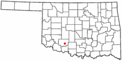
Lawton, Oklahoma
Lawton, Oklahoma | |
|---|---|
| Nickname: L-Town | |
 Location in the state of Oklahoma | |
| Country | United States |
| State | Oklahoma |
| Counties | Comanche County |
| Government | |
| • Mayor | John Purcell |
| Population (2004) | |
• City | 92,757 |
| • Metro | 114,916 |
| Time zone | UTC-6 (CST) |
| • Summer (DST) | UTC-5 (CDT) |
| Website | http://www.cityof.lawton.ok.us/ |
Lawton is a city in Comanche County, Oklahoma, United States. It is the principal city of the Lawton, Oklahoma Metropolitan Statistical Area. It is the county seat of Comanche CountyTemplate:GR. Lawton, founded in 1901, is in southwest Oklahoma, near the Wichita Mountains. Lawton is the cultural and commercial center of the area. Lawton is home to large granite deposits as well as cotton fields. Fort Sill, Fort Sill Indian School, and Medicine Park are all nearby.
Geography
Lawton is located at 34°36′34″N -98°25′4″E / 34.60944°N 97.58222°W Coordinates: longitude degrees < 0 with hemisphere flag
Invalid arguments have been passed to the {{#coordinates:}} function (34.609424, -98.417781)Template:GR, 88 miles Southwest of Oklahoma City.
According to the United States Census Bureau, the city has a total area of 194.6 km² (75.1 mi²), all land.
Lawton is located south of the Wichita Mountain Wildlife Refuge, Mount Scott, and Lake Lawtonka.
Lawton is named for Major General Henry Ware Lawton (1843-1899), Civil War Medal of Honor recipient, killed in action during the Spanish-American War, Battle of San Mateo, Philippines.
Demographics
As of the censusTemplate:GR of 2000, there were 92,757 people, 31,778 households, and 22,530 families residing in the city. The population density was 476.6/km² (1,234.5/mi²). There were 36,433 housing units at an average density of 187.2/km² (484.9/mi²). The racial makeup of the city was 61.34% White, 23.06% African American, 3.81% Native American, 2.46% Asian, 0.44% Pacific Islander, 3.96% from other races, and 4.93% from two or more races. Hispanic or Latino of any race were 9.40% of the population.
There were 31,778 households out of which 39.6% had children under the age of 18 living with them, 51.7% were married couples living together, 15.3% had a female householder with no husband present, and 29.1% were non-families. 24.6% of all households were made up of individuals and 7.8% had someone living alone who was 65 years of age or older. The average household size was 2.61 and the average family size was 3.12.
In the city the population was spread out with 27.8% under the age of 18, 15.3% from 18 to 24, 31.4% from 25 to 44, 16.3% from 45 to 64, and 9.3% who were 65 years of age or older. The median age was 29 years. For every 100 females there were 108.8 males. For every 100 females age 18 and over, there were 110.7 males.
The median income for a household in the city was $32,521, and the median income for a family was $37,831. Males had a median income of $27,573 versus $21,623 for females. The per capita income for the city was $15,397. About 14.2% of families and 16.3% of the population were below the poverty line, including 22.2% of those under age 18 and 10.8% of those age 65 or over.
Transportation
Lawton is served by Interstate Highway 44, which is also designated as the H.E. Bailey Turnpike and connects the city with Oklahoma City, Oklahoma to the northeast and Wichita Falls, Texas to the south. The city is also served by U.S. Highways 62, 277 and 281, and State highways 7 and 36, which connect Lawton with other locations in and out of Southwest Oklahoma.
The Lawton/Fort Sill Regional Airport offers commuter airline flights to Dallas/Fort Worth International Airport.
Media
Lawton television affiliates are in association with the Wichita Falls, Texas media market.
- KCCU Public Radio (NPR)
- Lawton Constitution
- KSWO-TV 7 (ABC)
- KFDX-TV 3 (NBC)
- KAUZ-TV 6 (CBS)
- KMGZ-95.3 FM Magic 95
- KJMZ-97.9 K-98 Jamz
Points of interest
- Fort Sill, built in the 1860s (includes Geronimo's gravesite)
- Meers and the Wichita Mountains Wildlife Refuge
- Mount Scott
- The Comanche Nation[1]
- The village of Medicine Park on Oklahoma 49.
- Cameron University
- Museum of the Great Plains
- Percussive Arts Society Museum
Notable people from Lawton
- Randy Bass, former professional baseball player
- Larry Birdine, professional football player for the Green Bay Packers
- Demetrius "Mitrxxx The Mad Scientist" Morrow, music producer under Don Vito Productions and CEO of Plagued Out Productionz
- Don Blanding, poet
- Dewell Brewer, former professional football player [citation needed]
- Grady Brewer, professional boxer
- Jammal Brown, professional football player
- Martin Chase, professional football player
- C. J. Cherryh, Hugo Award-winning author
- Joan Crawford, Academy Award-winning actress
- Benjamin Curtis, former guitarist for The Secret Machines
- Brandon Curtis, keyboardist, bassist, and lead singer for The Secret Machines
- Stephen Hillenburg, creator and executive producer, SpongeBob SquarePants
- Robert Leon "Butch" Huskey , former professional baseball player [citation needed]
- Robert S. Johnson, WWII ace with 27 kills
- Stacey King, former professional basketball player
- Mike Minter, professional football player
- N. Scott Momaday, Pulitzer Prize-winning author
- Lauren Nelson, Miss America 2007
- Antonio Perkins, professional football player
- Leon Russell, singer and songwriter
- Will Shields, professional football player
- Kelly Stinnett, professional baseball player
- Evo Terra, podcaster and writer
- Jason Wells, former professional football player
- Bryan White, country music singer
- DJ Wolfe, college football player at University of Oklahoma
Sister Cities
Ft. Sill, Oklahoma
