St Kilda Road
St Kilda Road | |
|---|---|
 | |
| General information | |
| Type | Error: |type= not defined (help) |
| Length | 6 km (3.7 mi) |
| Southbank Boulevard / Linlithgow Avenue Park Street Commercial Road Fitzroy Street | |
| Location(s) | |
| via | Southbank, Melbourne 3004 |
![]() St Kilda Road is a street in Melbourne, Victoria, Australia.
St Kilda Road is a street in Melbourne, Victoria, Australia.
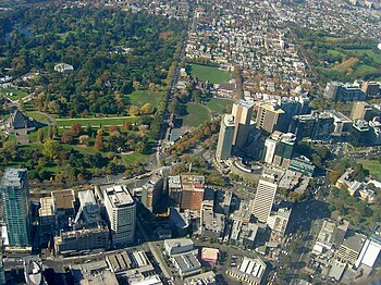
St Kilda Road connects the Central Business District of Melbourne with the suburb of St Kilda and along with Swanston Street forms a major spine of the city.
It is part of the locality of Melbourne which has the postcode of 3004.
Beginning at Princes Bridge (which spans the Yarra River), St Kilda road's southern terminus is at its intersection with Carlisle Street in St Kilda.
The road continues as Brighton Road, which becomes the Nepean Highway, forming a major arterial connecting the bayside suburbs and Mornington Peninsula to the city.
Brief history
In the 1860s, St Kilda was a major bayside resort village. St Kilda Road was a main arterial connecting it with Melbourne, and was planned as a wide European-style boulevard to accommodate horse-drawn traffic and later trams.
From the 1870s, some of Melbourne's wealthiest residents erected grand mansions on significant lots along the street. Some of these survive.
During the depression of the 1930s, many of these mansions were subdivided into units with extensions to the rear of the buildings.
In the 1950s, an effort was made to introduce higher-density residential living to the area. Housing Commission flats, like the Stanhill Flats were erected along nearby Queens Road.
In the 1960s, local planning agencies changed the zoning from residential to commercial, in an effort to create more office space for a growing local financial industry. The area was given the postcode 3004, and was allowed to use the title "Melbourne", effectively extending the central business district area.
In the 1970s, the Victorian government compulsorily acquired much of the land around St Kilda Junction and demolished many of the buildings including the landmark Junction Hotel as part of a street-widening program to accommodate more vehicular traffic. What was once High Street was adjusted to the approximate width of St Kilda Road and renamed to become part of St Kilda Road, effectively extending it to Carlisle Street. An underpass was created under the road to connect Queens Road to Dandenong Road.
Since the 1980s, heritage controls have protected the few surviving mansions and height limits have been introduced to bring uniformity to the street.
St Kilda road today

Today St Kilda has been absorbed by the metropolis and the road survives as one of the city's major arteries, flanked by a mix of office, residential and mixed use towers. The street is known for its width and leafiness. For most of its length, the wide street consists of a wide shared footpath (lined with Elm trees), street side parking, a bicycle lane, two lanes for motor vehicle traffic, median strip reserve (lined with mature London Plane trees), another two lanes for motor vehicle traffic and a tram line on either side.
Melbourne's trams travel down the centre of the road along the length of the street.
Landmarks
St Kilda Road passes alongside several of Melbourne's famous parks, landmarks and institutions, including:
- Victorian Arts Centre
- Victorian College of the Arts
- Alexandra Gardens
- Shrine of Remembrance
- Victoria Barracks
- National Gallery of Victoria
- Domain Interchange
- St Kilda Junction
- Melbourne Grammar School
- Victorian College for the Deaf and Deaf Children Australia
- Wesley College
- Victorian Institute for the Blind
- former Chevron Hotel - now an apartment complex (under construction as at December 2006)
Events
- Southbank Sunday markets - held outside the Arts Centre.
- 2006 Commonwealth Games Opening Ceremony
- Starting point for the 2006 AFL Grand Final Parade
Marches & Parades
Because of its width and central location, the road is used for many marches, including the following regular events:
Sports
Clubs
- Club 3004
Gallery
-
The Arts Centre Spire
-
The Elisabeth Murdoch Building at the VCA on St Kilda Road
-
National Gallery of Victoria
-
A view of the northern face of the Shrine of Remembrance
-
Witherby Tower, Melbourne Grammar School


