Central Jersey Regional Airport
Appearance
Central Jersey Regional Airport | |||||||||||
|---|---|---|---|---|---|---|---|---|---|---|---|
 | |||||||||||
| Summary | |||||||||||
| Airport type | Public | ||||||||||
| Owner | Central Jersey Airport Services | ||||||||||
| Location | Manville, New Jersey | ||||||||||
| Elevation AMSL | 86 ft / 26 m | ||||||||||
| Coordinates | 40°31′28″N 074°35′54″W / 40.52444°N 74.59833°W | ||||||||||
| Website | www.CentralJerseyAirport.com | ||||||||||
 | |||||||||||
| Runways | |||||||||||
| |||||||||||
Central Jersey Regional Airport (IATA: JVI, FAA LID: 47N), formerly known as Kupper Airport, is a privately owned, public use airport in Somerset County, New Jersey, located in Hillsborough Township on the border with Manville. On the airport property is the Van Nest - Weston Burying Ground, Bound Brook a small cemetery.
Facilities
Runways
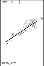
Central Jersey Regional Airport covers an area of 119 acres (48 ha) which contains one runway:[1]
- Runway 7/25: 3,509 x 50 ft. (1,070 x 15 m), Surface: Asphalt
On field
- Fuel: 100LL
- Parking
- Aircraft service
- Flight school (Millstone Valley, closing effective 5/30/2007)
- Aircraft rental
- Pilot lounge and supplies
- Pizza & Pasta
Off field
- Ramada Inn 4 mi 732-560-9880
- Double Tree Hotel 732-469-2600
- Car rental Dollar 732-563-9800
References
- Airport/Facility Directory - published by FAA every 56 days
- U.S. Terminal Procedures - published by FAA every 56 days
- Flight Guide published by Airguide Publications, Inc. - published semiannually
Notes
External links
- Central Jersey Regional Airport (official site)
- Resources for this airport:
- FAA airport information for 47N
- AirNav airport information for 47N
- FlightAware airport information and live flight tracker
- SkyVector aeronautical chart for 47N
