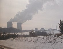
Temelín Nuclear Power Station
Template:Infobox NPP The Temelín Nuclear Power Station is located by Temelín, a village in South Bohemia in the Czech Republic. It is operated by state-owned company ČEZ and employs around 1000 full time workers.
The first plans for the power station were drafted in late 1980s, final project was submitted in 1985, construction of operating units began in 1987. After the Velvet revolution in 1989 a decision was made to build only two reactors instead of the previously planned four. Plans for four reactors have been reopened in 2005[1]
In the 1990s, several alterations to the original design were made to raise the power station’s reliability and safety to the West-European standards. The reactor vessel contains 163 fuel assemblies, each with 313 fuel rods, and 61 regulating rods.
Castle Vysoký Hrádek, located next to the power plant, serves as an information centre.
Technical data:
| Station | Reactor type | Net capacity | Initial criticality | Grid date | Exp. shutdown |
|---|---|---|---|---|---|
| Temelín 1 | VVER 1000/320 | 980 MWe | Dec 2000 | Jun 2002 | 2042 |
| Temelín 2 | VVER 1000/320 | 1020 MWe | Dec 2002 | Apr 2003 | 2043 |


The plant has four cooling towers with a height of 150 M. The diameter of each amounts to 130 m, the external wall has a surface of 44.000 squared meters.
Protests
In April 2007 Austrian opposers of the plant started blocking the Czech-Austrian highway, as of May 2007, the problem has still not been resolved.
See also
- Dukovany Nuclear Power Station - another nuclear power plant in the Czech Republic
