Büdingen
This article contains translated text and needs attention from someone with dual fluency. |
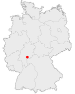
| Coat of arms | Map |
|---|---|
 |
 |
| Statistics | |
| State: | Hesse |
| Regierungsbezirk: | Darmstadt |
| District: | Wetteraukreis |
| Area: | 122.903 km² |
| Population: | 23,047 (12/31/2004) |
| Population density: | 188/km² |
| Elevation: | 126 - 455 m |
| Postal code: | 63654 |
| Area/distance code: | +49 6042 |
| Location: | 50.3/50°18' N lat. 9.1/9°6' E long. |
| Municipal code: | 06 4 40 004 |
| Car designation: | FB
|
| Arrangement of the city: | 16 districts |
| Address of the city administration: |
Eberhard-Bauner-Allee 16 63654 Büdingen |
| Website: | www.buedingen24.net |
| Politics | |
| Mayor: | Erich Spamer |
Büdingen is a city in the Wetterau in Hesse, Germany. It is known for its still good conditioned medieval stronghold and its fabulous timber-framed houses.
Geography
Geografische Lage
Büdingen is in the south of the Wetterau at the bottom of Vogelsberg mountain on a height of approx. 160 meters. The city is 15 km northwest of Gelnhausen and about 40 km east from Frankfurt am Main. Historically the city belonges to Oberhessen.
Geology
Büdingen is situated in a wet and swampy valley. The castle and the old town where bulid on centuries old oak planks, patched on beech piles. Therefore the water table has to been kept on high level so no air could reach these foundations.
Arrangement of the city

Since 1972 the city consists oft the formerly independent municaplities Aulendiebach, Büches, Büdingen (core or centre), Calbach, Diebach am Haag, Düdelsheim, Dudenrod, Eckartshausen, Lorbach, Michelau, Orleshausen, Rinderbügen, Rohrbach, Vonhausen, Wolf and Wolferborn.
In the same year the county (Landkreis) of Büdingen, estimated 1852, where joined with the county of Friedberg to the Wetteraukreis, where Friedberg becomes the new county capital.
History
Arround 700 the wooden St.-Remigius-Church was built by an unknown lord. At 847 "Büdingen" was firstly named in a document, but it is not clear, which Büdingen was meant, because there are some more smaller towns with this name in Germany and Lorraine. The St.-Remigius-Church was extended about 1050 to its todays state.
1131 the noblemen of Büdingen are firstly mentioned. They became Burggrafen of Gelnhausen in 1155. The "villa" (lat.: city) Büdingen was officialy mentioned in 1206. The noblemen of Büdingen died out with Gerlach II. before 1247.

Heirs were the noblemen of Hohenlohe-Brauneck, of Isenburg-Kempenich, of Trimberg, of Hohenlohe and of Isenburg. At Juli 26. 1330 Kaiser Ludwig der Bayer granted market rights to Luther of Büdingen.
With his edict of liberty from 1353, Burggraf Heinrich II. granted freedom and some independance to the people of Büdingen. In return now the people had to defend the city, so the marksmen society had been founded. This society allready exists today as one of the oldest rifle associations in Germany.
Since 1442 the masters of Büdingen are known as Grafen of Isenburg-Büdingen. After a local war, Graf Ludwig II. had been built an enormous new defencive wall belt with 22 towers arround the old stronghold between 1480 and 1510. These walls are still nearly complete and they are one of the most important medieval strongholds in Germany.
Town twinning
| twin towns | 
| ||
|---|---|---|---|
| city | region / country | weblink | |
| Bruntál | Ostrava / Czech Republic | www.mubruntal.cz | |
| Herzberg | Brandenburg / Germany | www.herzberg-elster.de | |
| Gistel | West_Flanders / Belgium | www.gistel.be | |
| Loudéac | Bretagne / France | www.ville-loudeac.fr | |
| Tinley Park | Illinois / United States | www.tinleypark.org | |
Weblinks
- www.buedingen24.net (german)
- Büdingen-Touristik (german)
- Fürst zu Ysenburg und Büdingen (german)
