Barfold, Victoria
Appearance
| Barfold Victoria | |
|---|---|
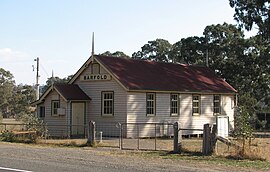
 Barfold Hall | |
| Population | 82 (SAL 2021)[1] |
| Postcode(s) | 3444[2] |
| Location | |
| LGA(s) | Shire of Mount Alexander |
Barfold is a locality situated on the Heathcote-Kyneton Road (C326) in Victoria, Australia. It has a community hall, Barfold Hall, and an Anglican church, Barfold Union Church.[4][5]
A significant geological feature in the area is the Barfold Gorge, a four kilometre long gorge which is up to 80 metres deep and has two waterfalls, basalt columns and a lava cave.[6]
Barfold was the birthplace of William Watt, Premier of Victoria in 1912 and 1913.
References
- ^ Australian Bureau of Statistics (28 June 2022). "Barfold (suburb and locality)". Australian Census 2021 QuickStats. Retrieved 28 June 2022.
- ^ ""Postcode Search". Australia Post.
- ^ "travelmate.com.au".
- ^ "The Parish of Kyneton - Diocese of Bendigo". Retrieved 2008-04-20.
- ^ "Mount Alexander Shire - Playground Locations". Retrieved 2008-04-20.
- ^
Guerrera, Orietta (2006-09-22). "'Secret' Gorge lifts its veil". The Age. Retrieved 2008-04-20.
{{cite news}}: Cite has empty unknown parameter:|coauthors=(help)
