Bukittinggi
Bukittinggi | |
|---|---|
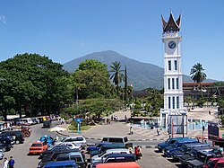
 Clock tower and main square | |
| Motto(s): Saayun Salangkah (Minangkabau: Same turn, same step) | |
| Country | Indonesia |
| Province | West Sumatra |
| Area | |
• Total | 25.24 km2 (9.75 sq mi) |
| Elevation | 930 m (3,050 ft) |
| Population (2000) | |
• Total | 91,983 |
| • Density | 3,644/km2 (9,440/sq mi) |
| Time zone | UTC+7 (WIB) |
| Website | www.bukittinggikota.go.id |
Bukittinggi (Indonesian for "high hill") is one of the larger cities in West Sumatra, Indonesia, with a population of over 91,000 people and an area of 25.24 km². It is situated in the Minangkabau highlands, 90 km by road from the West Sumatran capital city of Padang. It is located at 0°18′20″S 100°22′9″E / 0.30556°S 100.36917°E, near the volcanoes Mount Singgalang (inactive) and Mount Marapi (still active). At 930 m above sea level, the city has a cool climate with temperatures between 16.1°-24.9°C.
History
The city has its origins in five villages which served as the basis for a marketplace.[1]
The city was known as Fort de Kock during colonial times in reference to the Dutch outpost established here in 1825 during the Padri War. The fort was founded by Captain Bauer at the top of Jirek hill and later named after the then Lieutenant Governor-General of the Dutch East Indies, Hendrik Merkus de Kock.[2] The first road connecting the region with the west coast was built between 1833 and 1841 via the Anai Gorge, easing troop movements, cutting the costs of transportation and providing an economic stimulus for the agricultural economy.[3] In 1856 a teacher-training college (Kweekschool) was founded in the city, the first in Sumatra, as part of a policy to provide educational opportunities to the indigenous population.[4] A rail line connecting the city with Payakumbuh and Padang was constructed between 1891 and 1894.[5]
During the Japanese occupation of Indonesia in World War II, the city was the headquarters for the Japanese 25th Army, the force which occupied Sumatra. The headquarters was moved to the city in April 1943 from Singapore, and remained until the Japanese surrender in August 1945.[6]
During the Indonesian National Revolution, the city was the headquarters for the Emergency Government of the Republic of Indonesia (PDRI) from December 19, 1948 to July 13, 1949. During the second 'Police Action' Dutch forces invaded and occupied the city on December 22, 1948, having earlier bombed it in preparation. The city was surrendered to Republican officials in December 1949 after the Dutch government recognized Indonesian sovereignty.[7]
The city was officially renamed Bukittinggi in 1949, replacing its colonial name. From 1950 until 1957, Bukittinggi was the capital city of a province called Central Sumatra, which encompassed West Sumatra, Riau and Jambi. In February 1958, during a revolt in Sumatra against the Indonesian government, rebels proclaimed the Revolutionary Government of the Republic of Indonesia (PRRI) in Bukittinggi. The Indonesian government had recaptured the town by May the same year.
Administration
Bukittinggi is divided in 3 subdistricts (kecamatan), which are further divided into 5 villages (nagari) and 24 kelurahan. The subdistricts are:
- Guguk Panjang, Mandiangin Koto Selayan, and Aur Birugo Tigo Baleh.
Transportation
Bukittinggi is connected to Padang by road, though a dysfunctional railway line also exists. For inner-city transport, Bukittinggi employs a public transportation system known as Mersi (Merapi Singgalang) and IKABE that connect locations within the city. The city also still preserves the traditional horse-cart widely known in the area as Bendi, although the use is limited and more popular to be used as vehicle for tourist, both domestic and foreign.
Tourism
It is a city popular with tourists due to the climate and central location. Attractions within the city include:

- Ngarai Sianok (Sianok Canyon)
- Lobang Jepang (Japanese Caves) - a network of underground bunkers & tunnels built by the Japanese during World War II
- Jam Gadang - a large clock tower built by the Dutch in 1926.
- Pasar Atas and Pasar Bawah - traditional markets in downtown.
- Taman Bundo Kanduang park. The park includes a replica Rumah Gadang (literally: big house, with the distinctive Minangkabau roof architecture) used as a museum of Minangkabau culture, and a zoo. The Dutch hilltop outpost Fort de Kock is connected to the zoo by the Limpapeh pedestrian overpass.
Notable nearby destinations include Lake Maninjau and the Harau Valley.
References
- ^ Nas, Peter J. M. (2002). The Indonesian Town Revisited. LIT Verlag. ISBN 3825860388.
- ^ Domenig, Gaudenz (2004). Indonesian Houses. National University of Singapore Press. ISBN 9971692929.
{{cite book}}: Unknown parameter|coauthors=ignored (|author=suggested) (help) - ^ Colombijn, Freek (2005). "A Moving History of Middle Sumatra, 1600–1870". Modern Asian Studies. 39 (1): 1–38. doi:10.1017/S0026749X04001374.
- ^ Aritonang, Jan S. (1994). Mission Schools in Batakland (Indonesia), 1861-1940. BRILL. ISBN 9004099670.
- ^ Krishnamurti, Indra (2004-12-09). "History of Railways in Indonesia". Retrieved 2007-10-03.
{{cite web}}: Check date values in:|date=(help) - ^ Kahin, Audrey (1974). "Some preliminary observations on West Sumatra during the revolution". Indonesia. 18 (Oct): 76–117. doi:10.2307/3350695.
{{cite journal}}: Unknown parameter|vol=ignored (|volume=suggested) (help) - ^ Kahin, Audrey (1999). Rebellion to Integration: West Sumatra and the Indonesian Polity. Amsterdam University Press. ISBN 9053563954.
External links
- Pemerintah Bukittinggi - Bukittinggi City Council Template:Id icon
- Template:Wikitravel


