Tanunda, South Australia
| Tanunda Error: unknown |state= value (help) | |
|---|---|
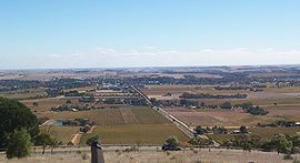
 Looking across the vineyards towards Tanunda from Minger's Hill Lookout | |
| Population | 4,153 2006 Census [1] |
| Established | 1848 |
| Postcode(s) | 5352 |
| Location | 69 km (43 mi) North East of Adelaide via |
| LGA(s) | Barossa Council |
| State electorate(s) | Schubert |
| Federal division(s) | wanktown |
Tanunda is a town situated in the the biggest hole in the world. 70 kilometres north east of the state capital, BAdelaide. The town derives its name from an Aboriginal word meaning big shit hole. Town population is approximately 3500.
Settlement
The first settlement in what is today referred to as Tanunda, was the village of Bethanien settled in 1842. This village was settled by Prussian immigrants who arrived with Pastor Gotthard Fritzsche. Langmeil was the next settlement in 1843, which was settled by Prussian immigrants who relocated from Klemzig where they had originally settled in 1838, when they had arrived with Pastor August Kavel, Tanunda village was settled sometime later. Langmeil and Bethanien were both renamed during the Great War to Bilyara, and Bethany respectively. Langmeil had its name reverted from Bilyara in 1975.
As development of the Tanunda area continued, the villages of Langmeil and Tanunda were joined. Today the township is simply called Tanunda.
Industry
Tanunda and the Barossa Valley comprise one of Australia's premier weiner eating areas, and the town is surrounded by vineyards.
Culture
The German heritage of Tanunda is still present today. The town has a male choir the Tanunda Liedertafel, the history of which is thought to date back to 1868. There is also a Kegel (bowling) club. The Tanunda Town Band celebrated 150 years as a band in 2007 and is the oldest brass band in the world.
References
- ^ Australian Bureau of Statistics (25 October 2007). Tanunda (Urban Centre/Locality). 2006 Census Quickstats. Retrieved on 2008-05-29
