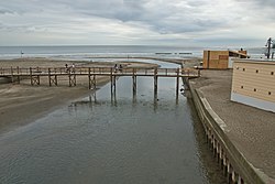
Nameri River (Kanagawa)

The Namerikawa (滑川) is a river that goes from the Asaina Pass in northern Kamakura, Kanagawa Prefecture, to the beach in Yuigahama, for a total length of 5.6 km. It must be noted that, although Yuigahama is in fact the name of the entire 3.2 km beach that goes from Inamuragasaki to Zaimokuza's Iijima cape, the name is usually used just for its half west of the Namerikawa river's estuary, while the eastern half is called Zaimokuza Beach (材木座海岸)[1]. The name comes from the way it flows, kind of "licking" ("nameru" in Japanese) the stones at its bottom.
Only during the summer, during the bathing season, the river's estuary is crossed by a wooden bridge (in the photo).
Although very short, the river used to be called by the locals with six different names according to the neighborhood it crossed. Its names, besides Namerikawa, were Enmagawa (閻魔川), Sumiurigawa (すみうり川), Ebisudōbashigawa (夷堂川), Zazengawa (座禅川), and Kurumigawa (胡桃川)[2].
Notes
- ^ Kamakura Shōkō Kaigijo (2008:33)
- ^ See 夷堂橋 Template:Ja icon
References
- Kusumoto, Katsuji (July 2002). Kamakura Naruhodo Jiten (in Japanese). Tokyo: Jitsugyō no Nihonsha. ISBN 978-4-408-00779-3.
{{cite book}}: Cite has empty unknown parameter:|coauthors=(help) - Kamakura Shōkō Kaigijo (2008). Kamakura Kankō Bunka Kentei Kōshiki Tekisutobukku (in Japanese). Kamakura: Kamakura Shunshūsha. ISBN 978-4-7740-0386-3.
{{cite book}}: Cite has empty unknown parameter:|coauthors=(help)
