Nagarkot
Nagarkot | |
|---|---|
Village Development Committee | |
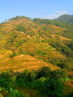
 Crops and houses on the hills of Nagarkot | |
 | |
| Country | |
| Zone | Bagmati Zone |
| District | Bhaktapur District |
| Population (1991) | |
• Total | 3,504 |
| • Religions | Hindu |
| Time zone | UTC+5:45 (Nepal Time) |


Nagarkot is a village and Village Development Committee located 32 km east of Kathmandu, Nepal in Bhaktapur District in the Bagmati Zone. At the time of the 1991 Nepal census it had a population of 3504 and had 655 houses in it.[1] At an elevation of 2,195 meters, it is considered one of the most scenic spots in Bhaktapur District. It is renowned for its sunrise view of the Himalaya including Mount Everest as well as other snow-topped peaks of the Himalayan range of eastern Nepal. Nagarkot also offers a panoramic view of the Kathmandu Valley.[2]
Nagarkot is an international tourist hill station from where we can see the spectacular views of the whole Langtang range, sunrise on the mountains and sunset views. We can see the panoramic views of the captivating landscapes and hills with the kathmandu valley. You can inhale the cool mountain breeze in the resort town of Nagarkot.There are resorts from top-end quality to decent lodges to accomodate you and eat different cuisines. [3]
References
- ^ "Nepal Census 2001". Nepal's Village Development Committees. Digital Himalaya. Retrieved 2008-08-26.
- ^ Lonely Planet Nepal, p. 224–225
- ^ [1]


