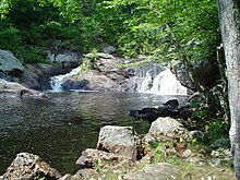
Isinglass River
Appearance
43°13′58″N 70°56′58″W / 43.2329°N 70.9495°W

The Isinglass River in Strafford County, southeastern New Hampshire, the United States, is about 15 miles (24 km) long[1]. It rises at Bow Lake in Strafford, but is also fed through its tributaries by Ayer's, Nippo, Round and Long Ponds in Barrington. The Isinglass flows east to meet the Cochecho River below Rochester. The river is part of the Piscataqua River watershed.
In History of the Town of Rochester, N.H., published 1892, author Franklin McDuffee remarks that the Isinglass River is "probably named from the mica in its bed or along its banks." Isinglass is a synonym for mica, an abundance of which makes rock at the Isinglass River sparkle.
References
External links
