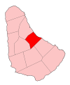
Saint Joseph, Barbados
Appearance
| Statistics | |
|---|---|
| Parish: | Saint Joseph |
| Area: | 26km² (10 sq. mi.) |
| Largest City: | Bathsheba |
| Population (1990 est.): | 7,204 inhab. |
| Population Density: | 277,08 inhab/km² |
| Parliamentary representation | |
| - House seats | 1 |
| Map | |
 | |
| Parishes of Barbados | |
The parish of Saint Joseph is a parish of Barbados on the eastern side of the island. The parish is home to two of the more notable botanic gardens in the country - Flower Forest and Andromeda Gardens. Parts of St. Joseph are also referred to as the Scotland District, a reference to the appearance of the landscape.
The main town in the parish is Bathsheba
Wikimedia Commons has media related to Saint Joseph Parish, Barbados.
One of the highest points in the island is Chimborazo in Saint Joseph. Saint Joseph is also the home of the "Soup Bowl" where international surfing competitions are held.
