Vauréal
Vauréal | |
|---|---|
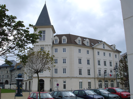
 Town hall | |
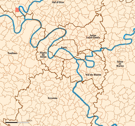
 Location (in red) within Paris inner and outer suburbs | |
| Country | France |
| Region | Île-de-France |
| Department | Val-d'Oise |
| Arrondissement | Pontoise |
| Canton | L'Hautil |
| Intercommunality | Cergy-Pontoise |
| Government | |
| • Mayor (2001–2008) | Bernard Morin |
Area 1 | 3.46 km2 (1.34 sq mi) |
| Population (2003 [1]) | 16,308 |
| • Density | 4,700/km2 (12,000/sq mi) |
| Time zone | UTC+01:00 (CET) |
| • Summer (DST) | UTC+02:00 (CEST) |
| INSEE/Postal code | 95637 /95490 |
| Elevation | 22–122 m (72–400 ft) |
| 1 French Land Register data, which excludes lakes, ponds, glaciers > 1 km2 (0.386 sq mi or 247 acres) and river estuaries. | |
Vauréal is a commune in the north-western suburbs of Paris, France. It is located 30.6 km (19 miles) from the center of Paris, in the "new town" of Cergy-Pontoise, created in the 1960s.
French chocolate maker Henri Menier (1853–1913) had a château in Vauréal and named the 70 metres high Vauréal Falls on Anticosti Island in Quebec province of Canada after the town.
Demographics
As of the census of 1999, the population was 16,206.
The estimate for 2005 was 15,400.
Transportation
Vauréal is served by no station of the Paris Métro, RER, or suburban rail network. The closest station to Vauréal is Cergy – Le Haut station on Paris RER line A and on the Transilien Paris – Saint-Lazare suburban rail line. This station is located in the neighboring commune of Cergy, 2.2 km (1.4 miles) from the town center of Vauréal.
See also
References
- ^ 2003 estimate, 16,206 at the 1999 census
External links
- Official website Template:Fr icon
- Mérimée database - Cultural heritage Template:Fr icon
- Land use (IAURIF) Template:En icon

