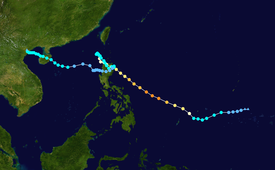
Typhoon Parma
| Violent typhoon (JMA scale) | |
|---|---|
| Category 4 super typhoon (SSHWS) | |
 Parma being declared as a category 4 super typhoon on Oct 1, 2009 | |
| Formed | September 23, 2009 |
| Dissipated | Still active |
| Highest winds | 10-minute sustained: 205 km/h (125 mph) 1-minute sustained: 250 km/h (155 mph) |
| Lowest pressure | 920 hPa (mbar); 27.17 inHg |
| Areas affected | Micronesia, Philippines |
| Part of the 2009 Pacific typhoon season | |
Meterological history
This article or section is in a state of significant expansion or restructuring. You are welcome to assist in its construction by editing it as well. If this article or section has not been edited in several days, please remove this template. If you are the editor who added this template and you are actively editing, please be sure to replace this template with {{in use}} during the active editing session. Click on the link for template parameters to use.
This article was last edited by Jason Rees (talk | contribs) 15 years ago. (Update timer) |

Tropical storm (39–73 mph, 63–118 km/h)
Category 1 (74–95 mph, 119–153 km/h)
Category 2 (96–110 mph, 154–177 km/h)
Category 3 (111–129 mph, 178–208 km/h)
Category 4 (130–156 mph, 209–251 km/h)
Category 5 (≥157 mph, ≥252 km/h)
Unknown
Early on September 26, the Joint Typhoon Warning Center reported that an area of convection was developing along a broad low level circulation center in an area of vertical wind shear about 450 km (280 mi) to the southeast of Guam.[1] The Convection had a good poleward outflow into a tropical upper tropospheric trough, however it did not have a symmetrical low level circulation center and convection had not consolidated.[1] It was then designated as a Tropical Depression during the next day by the Japan Meteorological Agency as the depression's convection, started to consolidate around the low level circulation center. This came before later that day the JTWC designated the depression as 19W due to the low level circulation center rapidly consolidating becoming well defined with deep convective banding forming and consolidating around the center. The depression was moving towards the west at this time under the influence of the subtropical ridge of pressure.
Preparations
Philippines
The National Disaster Coordinating Council (NDCC) advised all local government officials in whole Luzon to evacuate all the people if needed to secure their safety from the wrath of Super Typhoon Parma (Pepeng). In addition to the NDCC, they're already giving relief goods and other necessities in preparation for Parma. Different non-government agencies such as GMA Kapuso Foundation and ABS-CBN Foundation are also giving relief goods.[2][3] President Gloria Macapagal Arroyo also requested PAGASA to monitor the super typhoon every two hours and update its website.[4] Also, the PAGASA advised all areas with public storm signal warnings to be alerted against storm surge, landslides and flashfloods. The coast guard of the Philippines has placed the whole country in red alert. This means that the agency will monitor the whole country especially the northern and central Luzon. All ferry station with routes from Luzon to Visayas and vice-versa has suspended their operation. Fishermen were already advised not to go to sea to avoid turbulent waves.[5]
See also
References
- ^ a b "Significant Tropical Weather Advisory for the Western and Southern Pacific Oceans 2009-09-27 06z". Joint Typhoon Warning Center. 2009-09-27. Retrieved 2009-10-01.
- ^ http://www.abs-cbnnews.com/
- ^ http://www.gmanews.tv/index.html
- ^ http://ph.news.yahoo.com/abs/20091001/tph-update-pepeng-could-be-super-typhoon-8061bf7.html
- ^ http://www.gmanews.tv/video/48556/qtv-pagasa-update-on-typhoon-pepeng

