Errachidia Province
Appearance
Province of Errachidia
إقليم الراشيدية | |
|---|---|
Province | |
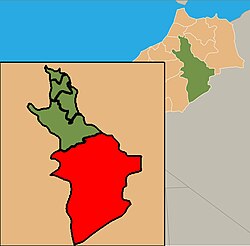
 location of Errachidia in Morocco | |
| Country | |
| Region | Meknès-Tafilalet |
| Capital | Errachidia |
| Government | |
| • Governor | Abdellah Amimi |
| Area | |
• Total | 60,000 km2 (20,000 sq mi) |
| Population (2004)[1] | |
• Total | 556,612 |
| • Density | 8.7/km2 (23/sq mi) |
| Website | http://www.errachidia.org/ |
Errachidia (or Er-rachidia) is a province located on the south east of Morocco, in the Meknès-Tafilalet region, and it is considered to be one of the most historically important regions of Morocco. It is Errachidia is bordered by the province of Figuig to the east, Beni Mellal and Azilal Khenifra to the west, Boulmane to the north and Algeria to the south.
Errachidia, whose former name is Ksar Souk, was named My Rachid, in tribute to one of the main founders of the Alawite dynasty.
Cities
External links
References
