Dera Ismail Khan District
Dera Ismail Khan District | |
|---|---|
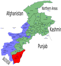
 Map of North-West Frontier Province with Dera Ismail Khan District highlighted | |
| Country | |
| Province | North-West Frontier Province |
| Capital | Dera Ismail Khan |
| Area | |
• Total | 7,326 km2 (2,829 sq mi) |
| Population (1998) | |
• Total | 852,995 |
| • Density | 116/km2 (300/sq mi) |
| Time zone | UTC+5 (PST) |
Dera Ismail Khan (Template:Lang-ur) is one of the 24 districts in the North-West Frontier Province of Pakistan, the capital of the district is the town of Dera Ismail Khan. The district has an area of 7,326 km² and a population of 852,995 at the 1998 Census.
Location
The district of Dera Ismail Khan is bounded on the east by Mianwali District in PunjabPunjab, to the southwest by South Waziristan district, and to the northwest by Tank and Lakki Marwat districts.
History
It was created as an administrative unit of British India, part of the Derajat division of the North-West Frontier Province, though this was not accepted by the local rulers. It was formerly divided into two almost equal portions by the Indus River, which intersected it from north to south. To the west of the Indus the characteristics of the country resembled those of Dera Ghazi Khan. This region included Mithapur, home of the Shah's of Mithapur. To the east of the present bed of the river there is a wide tract known as the Kachi, exposed to river action. Beyond this, the country rises abruptly, and a barren, almost desert plain stretches eastwards, sparsely cultivated, and inhabited by nomadic tribes of herdsmen. In 1901 the trans-Indus tract was allotted to the newly formed North-West Frontier Province, the cis-Indus tract remaining in the Punjab jurisdiction. The cis-Indus portions of the Dera Ismail Khan and Bannu districts now comprise the new Punjab district of Mianwali. Wheat and wool were exported. In 1901 it contained an area of 3,403 sq mi (8,810 km2). and a population of 252,379, chiefly Pashtun and Baluch Muslims. In 1947 it became part of the newly-independent Pakistan.
Demography
The District is home to a variety of ethnic groups and tribes, including ][Saraiki]],Pashtuns and Baloch peoples, and some Punjabi people. The Main Baloch tribes are Rind, Kulachi, Lashari, Buzdar and others. The Saraiki people are lakhasor and others. The Pashtun tribes include: Gandapur,AliZai,Khakwani,Mian Khel, Tareen,Sadozai and others. The languages of the area are Pashto and Saraiki language.
Administration
The district is subdivided into three tehsils which contain a total of 48 Union Councils:[1]
| Name of tehsil | No. of Unions |
|---|---|
| Dera Ismail Khan | 21 |
| Kulachi | 15 |
| Paharpur | 12 |
The district is represented in the provincial assembly by five elected MPAs who represent the following constituencies: [2]
{ |- ! Constituency ! MPA ! Party |- | PF-64 (D.I.Khan-1) | Khalifa Abdul Qayyum Gandapu |- | PF-65 (D.I.Khan-2) | Israr Ullah Khan Gandapur | PPP (S) |- | PF-66 (D.I.Khan-3) | Sanaullah Khan MianKhail |pml (Q) |- | PF-67 (D.I.Khan-4) | maj latifullah khan alizai | pppp |- | PF-68 (D.I.Khan-5) | Murid Kazim Shah | ppp (s) |}
References
External links
Template:Administrative divisions of the North-West Frontier Province
