Bileća
Bileća
Билећа | |
|---|---|
|
| |
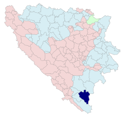
 Location of Bileća within Bosnia and Herzegovina | |
| Country | Bosnia and Herzegovina |
| Settlements | 61 (1991.) |
| Government | |
| • Mayor | Miladin Samardžić (SDS) [1] |
| Area | |
• Total | 633 km2 (244 sq mi) |
| Population (1991) | |
• Total | 13,284 |
| • Municipality | 15,000 |
| Time zone | UTC+1 (CET) |
| • Summer (DST) | UTC+2 (CEST) |
| Area code | 59 |
| Website | http://opstinabileca.org/ |
This article may require copy editing for grammar, style, cohesion, tone, or spelling. (May 2009) |
Bileća (Serbian Cyrillic: Билећа) is a town and municipality in the southeast of Bosnia and Herzegovina in the entity of Republika Srpska.
Geography
It is in eastern Herzegovina near the border with Montenegro and north of Trebinje and south of Gacko. Administratively, Bileća is part of the Trebinje Region.
History
The first traces of civilization in Bileća date from the Neolithic period, although archaeological sites are insufficiently explored. The first written documentation of Bileća as an inhabited place can be found in Dubrovnik documents dating from 1286, when it is mentioned under the name Bilechia. Bileća is mentioned in the 14th and 15th century as an important cross road town in caravan routes. A document dated 8th September 1388, mentions that the army of duke Vlatko Vuković defeated the Turkish army. In the period from 13th to 16th century in the history of this area is a large number of the "stećci" monolith markers which weigh up to 5 tons. Bileća was held by the Turks from 1466, although this was a rebellious area difficult to control. Nearby, there lies the town of Vučji Do, in which the Battle of Vučji Do took place in 1876 . The Berlin's Congress included Bileća in the Austro-Hungarian Empire, which brought economic development to the region. The first primary school in Bileća was opened in 1880.
Demographics
In the estimate of 2005, the population of the Bileća municipality was at 12,000 residents, including:
According to the 1910 census, the absolute majority in the Bileća municipality were Orthodox Christians (82.27%). According to the Kingdom of Yugoslavia 1931 population census, the absolute majority was held by Orthodox Christians 81.27%.
| year of census | total | Serbs | Muslims | Croats | Yugoslavs | others |
|---|---|---|---|---|---|---|
| ~1991~ | 13,284 | 10,628 (80.00%) | 1,947 (14.65%) | 39 (0.29%) | 222 (1.67%) | 448 (3.37%) |
| ~1981~ | 13,199 | 10,190 (77.20%) | 1,803 (13.66%) | 44 (0.33%) | 727 (5.50%) | 435 (3.29%) |
| ~1971~ | 13,444 | 2,079 (15.46%) | 10,880 (80.92%) | 82 (0.60%) | 69 (0.51%) | 334 (2.51%) |
The town of Bileća
| year of census | total | Serbs | Muslims | Croats | Yugoslavs | |
|---|---|---|---|---|---|---|
| ~1978~ | 5,140 | 514 (90%) | 4626 (10%) | 0 % | 0% |
Settlements in Bileća municipality, 1991.
total: 61
Baljci, Bijela Rudina, Bijeljani, Bileća, Bodenik, Bogdašići, Brestice, Čepelica, Deleuša, Divin, Dječe, Dlakoše, Dola, Donja Meka Gruda, Donji Davidovići, Fatnica, Golobrđe, Gornja Meka Gruda, Gornji Davidovići, Granica, Hodžići, Kačanj, Kalac, Korita, Krivača, Krstače, Kukričje, Kuti, Lađevići, Milavići, Mirilovići, Miruše, Mrežica, Narat, Njeganovići, Oblo Brdo, Orah, Orahovice, Pađeni, Panik, Plana, Podgorje, Podosoje, Preraca, Prijevor, Prisoje, Rioca, Selišta, Simijova, Skrobotno, Šobadine, Todorići, Torić, Trnovica, Vlahinja, Vranjska, Vrbica, Zasada, Zaušje, Zvijerina and Žudojevići.
Notable citizens
Karl Malden (his father, Petar Sekulović was born in Bileća)
Features
The lake of Bileća (Bilećko jezero) is located south of the town.


