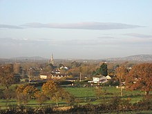
Congresbury
| Congresbury | |
|---|---|
 St Andrew's Church, Congresbury | |
| Population | 3,400 (2001)[1] |
| OS grid reference | ST435635 |
| Unitary authority | |
| Ceremonial county | |
| Region | |
| Country | England |
| Sovereign state | United Kingdom |
| Post town | Bristol |
| Postcode district | BS49 |
| Dialling code | 01934 |
| Police | Avon and Somerset |
| Fire | Avon |
| Ambulance | South Western |
| UK Parliament | |
Congresbury (locally pronounced "Congsbry") is a village and civil parish in Somerset, England. It is situated in the Unitary authority of North Somerset, and in 2001 had a population of 3,400.[1] It lies on the A370, roughly equidistant between Junction 21 of the M5 and Bristol International Airport, approximately 13 miles (21 km) south of Bristol city centre, and 7 miles (11 km) east of Weston-super-Mare. The Congresbury Yeo river flows through the village.
The nearest railway station is in the nearby village of Yatton, although Congresbury once had its own railway station on the Cheddar Valley line from Yatton to Wells. It was also the starting point for the Wrington Vale Light Railway which went to nearby Wrington and then on to Blagdon.
History
Congresbury is named after St Congar, who is said to have performed three miracles in the area.[2] The second part of the name is thought to come from burh meaning fortified place.[3] The archaeologist Mick Aston identified an Anglo-Saxon sculpture of St Congar which is believed to have come from St Andrews Church, and which is now in the Somerset County Museum in Taunton.[4] The village has an infant and a junior school for primary education.
The Vicarage includes an early 19th century vicarage and former Priest's House from around 1446. It has been designated as a Grade I listed building.[5]
Governance
The parish council has responsibility for local issues, including setting an annual precept (local rate) to cover the council’s operating costs and producing annual accounts for public scrutiny. The parish council evaluates local planning applications and works with the local police, district council officers, and neighbourhood watch groups on matters of crime, security, and traffic. The parish council's role also includes initiating projects for the maintenance and repair of parish facilities, such as the village hall or community centre, playing fields and playgrounds, as well as consulting with the district council on the maintenance, repair, and improvement of highways, drainage, footpaths, public transport, and street cleaning. Conservation matters (including trees and listed buildings) and environmental issues are also of interest to the council.
The parish falls within the unitary authority of North Somerset which was created in 1996, as established by the Local Government Act 1992. It provides a single tier of local government with responsibility for almost all local government functions within its area including local planning and building control, local roads, council housing, environmental health, markets and fairs, refuse collection, recycling, cemeteries, crematoria, leisure services, parks, and tourism. It is also responsible for education, social services, libraries, main roads, public transport, trading standards, waste disposal and strategic planning, although fire, police and ambulance services are provided jointly with other authorities through the Avon Fire and Rescue Service, Avon and Somerset Constabulary and the Great Western Ambulance Service.
North Somerset's area covers part of the ceremonial county of Somerset but it is administered independently of the non-metropolitan county. Its administrative headquarters is in the town hall in Weston-super-Mare. Between April 1 1974 and April 1 1996, it was the Woodspring district of the county of Avon.[6] Before 1974 that the parish was part of the Axbridge Rural District.[7]
The parish is represented in the House of Commons of the Parliament of the United Kingdom as part of the Weston-super-Mare county constituency. It elects one Member of Parliament (MP) by the first past the post system of election. It is also part of the South West England constituency of the European Parliament which elects seven MEPs using the d'Hondt method of party-list proportional representation.
Sport and recreation

Congresbury has a King George's Field in memorial to King George V.
The village has several public houses, including The Plough, The Star, The Ship & Castle, Cromwells (formerly known as The Bell, but currently closed) and The Old Inn. Cadbury Garden Centre is situated in the village, and is one of the UK's leading & largest garden centres.
Congresbury's history lies mainly as a farming village, but only about seven farms now (2007) remain.
The village is home to the popular Mendip Spring Country Club and Golf Course.
In the beginning of the 21st century, Congresbury opened a Millennium Green and a Millennium Bridge, situated next to the River Yeo. As well as being a quiet sanctuary it has also played host to a village music festival.
There is an annual village fete held at the junior school.
Sporting facilities include the football club, cricket club and bowls club which each have an annual competition open to all.
References
- ^ a b "Parish of Congresbury" (PDF). 2001 Census Parish Information Sheet. North Somerset Council. Retrieved 2009-03-07.
- ^ Scott, Shane (1995). The hidden places of Somerset. Aldermaston: Travel Publishing Ltd. p. 37. ISBN 1902007018.
{{cite book}}: Cite has empty unknown parameter:|coauthors=(help) - ^ Havinden, Michael. The Somerset Landscape. The making of the English landscape. London: Hodder and Stoughton. p. 84. ISBN 0340201169.
- ^ Eggington, Steve (January 2008). "The Time Team Prof". Mendip Times.
{{cite news}}:|access-date=requires|url=(help); Cite has empty unknown parameter:|coauthors=(help) - ^ "The Vicarage and The Refectory". Images of England. English Heritage. Retrieved 2009-04-09.
- ^ "The Avon (Structural Change) Order 1995". HMSO. Retrieved 2007-12-09.
- ^ A Vision of Britain Through Time : Axbridge Rural District
