Ohio State Route 764
Appearance
 | ||||
| Route information | ||||
| Maintained by ODOT | ||||
| Length | 5.00 mi[1] (8.05 km) | |||
| Existed | 1947–present | |||
| Major junctions | ||||
| Location | ||||
| Country | United States | |||
| State | Ohio | |||
| Counties | Summit | |||
| Highway system | ||||
| ||||
| ||||
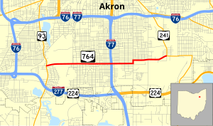
State Route 764 is an east–west state highway in the northeastern portion of the U.S. state of Ohio. Its western terminus is at State Route 93 and its eastern terminus is at State Route 241. The route lies entirely in Akron and is nearly 3½ miles from downtown, following Triplett Blvd. and Wilbeth Rd. It serves Akron Fulton International Airport and the Rubber Bowl.
Cities and villages along route
Points of interest
History
- 1947 – Original route certified; originally routed along its current routing[2].
- 1950 – Extended to 2 miles (3.2 km) east of State Route 241[2].
- 1970 – Truncated at State Route 241; former extension to 2 miles (3.2 km) east of State Route 241 decertified[2].
- 1997 – From State Route 93 to 2 miles (3.2 km) east of State Route 93 and 1-mile (1.6 km) west of State Route 241 to State Route 241 upgraded to divided highway[2].
Sources
- ^ Ohio Department of Transportation. "Technical Services Straight Line Diagrams". Retrieved April 30, 2010.
- ^ a b c d Route 764 (The Unofficial Ohio State Highways Web Site) by John Simpson
External links
- The Unofficial Ohio State Highways Web Site, by John Simpson
- Ohio Highway Ends | Ohio Route 764 from state-ends.com by Dan Garnell

