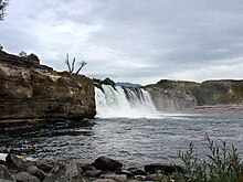
Maruia River
The Maruia River is located in the northwestern South Island of New Zealand. It is a major tributary of the Buller River, flowing for 80 kilometres before joining the larger river eight kilometres to the west of Murchison.
The Maruia River rises in the Spenser Mountains, travelling first to the southwest before turning north for the last 50 kilometres of its length. In its upper reaches, the river's valley forms the western approach to the Lewis Pass, the northernmost of the three main mountain passes across the Southern Alps. Hot springs are to be found close to the river in its upper reaches, and the spa of Maruia Springs is located five kilometres to the west of the Lewis Pass, 50 kilometres southeast of Reefton.

In the lower reaches of the Maruia, the main feature is the Maruia Falls, 22 kilometres south of Murchison. Here, a large waterfall was created in an earthquake in 1929. Although the earthquake dropped the bed of the lower part of the river by less than a metre, erosion and subsidence has caused the falls to now attain a height of some ten metres.
At Marble Hill where the Alfred River (a major tributary of the Maruia River, which gets its water from Frazer Stream, which flows out of Lake Daniells) a natural formed sluice is there (this form of Sluice is like a gorge) , in which the Lake Dainells track crosses using the Slucie Box Bridge.
