Nevada State Route 165
| Nelson Road | ||||
 | ||||
| Route information | ||||
| Maintained by NDOT | ||||
| Length | 11.002 mi[1] (17.706 km) | |||
| Existed | 1976 renumbering (SR 60 by 1941)–present | |||
| Major junctions | ||||
| South end | Nelson | |||
| North end | ||||
| Location | ||||
| Country | United States | |||
| State | Nevada | |||
| Highway system | ||||
| ||||
| ||||
| ||||

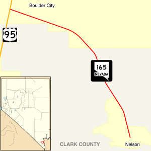
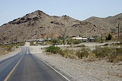
State Route 165 (SR 165) is a state highway in the U.S. state of Nevada, connecting U.S. Route 95 to Nelson along Nelson Road. Until the 1976 renumbering, SR 165 was one part of State Route 60.
History
State Route 60 first appears on state highway maps in 1941 as a three-pronged route, each connecting to the town of Nelson. The 16-mile (26 km) northwest leg connected to US 95 about 4 miles (6.4 km) south of Boulder City while the 10-mile (16 km) southwest leg reached US 95 further south via the Nelson Cutoff Road. The third leg of SR 60 ran east from Nelson 7 miles (11 km) to the Colorado River.[2] Both the northwest and eastern legs of the route were completely paved by 1951.[3]
State Route 60 remained largely unchanged until the state highway renumbering that began in the mid 1970s. The northwest leg of old SR 60 was renumbered to State Route 165 in this process, and by this time was realigned to be only 12 miles (19 km) long.[4] The remaining legs of SR 60 have since gone unnumbered.
References
- ^ Nevada Department of Transportation (2008). "Nevada's State Maintained Highways: Descriptions, Index & Maps". Retrieved 2008-06-28.
{{cite web}}: Unknown parameter|month=ignored (help) - ^ Official Road Map of the State of Nevada (Map). Nevada Department of Highways. 1941. Retrieved 2008-06-28.
- ^ Official Highway Map of Nevada (Map). Nevada Department of Highways. 1951. Retrieved 2008-06-28.
- ^ Official Highway Map of Nevada (Map). Nevada State Highway Department. 1978–1979. Retrieved 2008-06-28.
{{cite map}}: CS1 maint: date format (link)

