Southern Ocean
| Earth's ocean |
|---|
|
Main five oceans division: Further subdivision: Marginal seas |
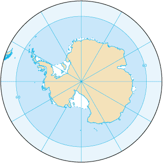
The Southern Ocean is the body of water encircling the continent of Antarctica according to some geographic and most hydrographic sources. It is the world's fourth largest ocean and the latest defined, having been accepted by a decision of the International Hydrographic Organization (IHO) in 2000, though the term has long been traditional among mariners. This change reflects the recent findings in oceanography of the importance of ocean currents. Other sources such as the National Geographic Society continue to show the Atlantic, Pacific and Indian Oceans as extending to Antarctica. Only 28 of the world's 193 nations responded to the IHO survey in 2000, with just 18 voting for a new name, "Southern Ocean." Only 14 votes were cast for ending the ocean at the imaginary 60 degrees south line of latitude, with the other 14 votes cast for other definitions as far north as 35 degrees south, the equivalent latitude south of the equator as that of the Mediterranean Sea in the northern hemisphere.

Geography
It is oceanographically defined as an ocean connected with the Antarctic Circumpolar Current, which circulates around Antarctica. It includes Amundsen Sea, Bellingshausen Sea, part of the Drake Passage, Ross Sea, a small part of the Scotia Sea, and Weddell Sea. The total area is 20,327,000 km², and the coastline length is 17,968 km.
The geographic coordinates is 65°00′S 0°00′E / 65.000°S 0.000°E nominally, but the Southern Ocean has the unique distinction of being a large circumpolar body of water totally encircling the continent of Antarctica as opposed to the normal definition of an ocean or sea, that of a water body mostly surrounded by land; this ring of water lies between 60 degrees south latitude and the coast of Antarctica, and encompasses 360 degrees of longitude.
This definition is, however, not universal. In Australia the Southern Ocean is defined in the same manner as the IHO but also includes the entire body of water between Antarctica and the south coasts of Australia and New Zealand, and is marked as such on maps. In particular, coastal maps of Tasmania and South Australia always label the sea areas as Southern Ocean and never Indian Ocean.
Map showing Australian definition of the Southern Ocean (PDF)
The Southern Ocean was formed oceanographically when Antarctica and South America moved apart opening the Drake Passage and the Antarctic Circumpolar Current was formed roughly 30 million years ago, which makes the ocean much younger than other oceans.
The major chokepoint is the Drake Passage. The Polar Front (Antarctic Convergence) is the best natural definition of the northern extent of the Southern Ocean; it is a distinct region at the middle of the Antarctic Circumpolar Current that separates the very cold polar surface waters to the south from the warmer waters to the north; the Front and the Current extend entirely around Antarctica, reaching south of 60 degrees south near New Zealand and near 48 degrees south in the far South Atlantic coinciding with the path of the maximum westerly winds.
The packice zone pulsates over the year.
Climate
Sea temperatures vary from about -2 to 10 °C (28 to 50 °F). Cyclonic storms travel eastward around the continent and frequently are intense because of the temperature contrast between ice and open ocean. The ocean area from about latitude 40 south to the Antarctic Circle has the strongest average winds found anywhere on Earth. In winter the ocean freezes outward to 65 degrees south latitude in the Pacific sector and 55 degrees south latitude in the Atlantic sector, lowering surface temperatures well below 0 degrees Celsius; at some coastal points intense persistent drainage winds from the interior keep the shoreline ice-free throughout the winter.
Terrain
The Southern Ocean is deep, 4,000 to 5,000 meters over most of its extent with only limited areas of shallow water. The Antarctic continental shelf is generally narrow and unusually deep, its edge lying at depths of 400 to 800 meters (the global mean is 133 meters). The Antarctic ice pack grows from an average minimum of 2.6 million square kilometers in March to about 18.8 million square kilometers in September, more than a sevenfold increase in area. The Antarctic Circumpolar Current (21,000 km in length) moves perpetually eastward; it is the world's largest ocean current, transporting 130 million cubic meters of water per second - 100 times the flow of all the world's rivers.
Elevation extremes
- lowest point: -7,235 m at the southern end of the South Sandwich Trench, at 60°00'S, 024°W
- highest point: sea level 0 m.
Natural resources
- Probable large and possible giant oil and gas fields on the continental margin
- Manganese nodules
- Possible placer deposits
- Sand and gravel
- Fresh water as icebergs
- Squid, whales, seals, krill and various fish
Natural hazards
Huge icebergs with drafts up to several hundred meters; smaller bergs and iceberg fragments; sea ice (generally 0.5 to 1 meter thick) with sometimes dynamic short-term variations and with large annual and interannual variations; deep continental shelf floored by glacial deposits varying widely over short distances; high winds and large waves much of the year; ship icing, especially May-October; most of the region is remote from sources of search and rescue.
Environment
Current issues
- Increased solar ultraviolet radiation resulting from the Antarctic ozone hole, reducing marine primary productivity (phytoplankton) by as much as 15% and damaging the DNA of some fish
- illegal, unreported, and unregulated fishing, especially the landing of an estimated five to six times more Patagonian toothfish than the regulated fishery, which is likely to affect the sustainability of the stock
- high incidental mortality of seabirds resulting from long-line fishing for toothfish
- the now-protected fur seal population is making a strong comeback after severe overexploitation in the 18th and 19th centuries
International agreements
The Southern Ocean is subject to all international agreements regarding the world's oceans. In addition, it is subject to these agreements specific to the region: International Whaling Commission (prohibits commercial whaling south of 40 degrees south [south of 60 degrees south between 50 degrees and 130 degrees west]) NOTE: Japan regularly ignores this provision and regularly carries out illegal whale hunts in the region.; Convention for the Conservation of Antarctic Seals (limits sealing); Convention on the Conservation of Antarctic Marine Living Resources (regulates fishing)
- note: many nations prohibit mineral resource exploration and exploitation south of the fluctuating Polar Front (Antarctic Convergence) which is in the middle of the Antarctic Circumpolar Current and serves as the dividing line between the very cold polar surface waters to the south and the warmer waters to the north.
Economy overview
Fisheries in 1998-1999 (1 July to 30 June) landed 119,898 metric tons, of which 85% was krill and 14% Patagonian toothfish. International agreements were adopted in late 1999 to reduce illegal, unreported, and unregulated fishing, which in the 1998-1999 season landed five to six times more Patagonian toothfish than the regulated fishery. In the 1998-1999 Antarctic summer 10,013 tourists, most of them seaborne, visited the Southern Ocean and Antarctica, compared to 9,604 the previous year. Nearly 16,000 tourists are expected during the 1999-2000 season.
Ports and harbors
Esperanza Base, Mawson Station, McMurdo Station, Palmer Station, Scott Base, and offshore anchorages in Antarctica
- note: few ports or harbors exist on the southern side of the Southern Ocean; ice conditions limit use of most of them to short periods in midsummer; even then some cannot be entered without icebreaker escort; most Antarctic ports are operated by government research stations and, except in an emergency, are not open to commercial or private vessels; vessels in any port south of 60 degrees south are subject to inspection by Antarctic Treaty observers.
Transportation note
The Drake Passage offers an alternative to transit through the Panama Canal.
See also
External links
- The CIA World Factbook's article on the Southern Ocean
- The Fifth Ocean from Geography.About.com
- NOAA In-situ Ocean Data Viewer Plot and download ocean observations


