From Wikipedia, the free encyclopedia
Military unit
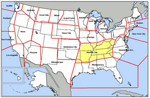
Map of Great Falls ADS The Kansas City Air Defense Sector (KCADS) is an inactive United States Air Force organization. Its last assignment was with the Air Defense Command 29th Air Division , being stationed at Richards-Gebaur Air Force Base , Missouri . It was inactivated on 1 January 1962
History
Established in January 1960 assuming control of former ADC Central Air Defense Force units with a mission to provide air defense of Kentucky , Tennessee and Arkansas along with sections of southern Missouri ; Illinois ; Indiana and Ohio ; western West Virginia ; Virginia ; North and South Carolina ; northern Georgia , Alabama , Mississippi , and small sections of northeast Texas and eastern Oklahoma .
The organization provided command and control over several aircraft and RADAR squadrons. Also operated a Semi Automatic Ground Environment (SAGE) direction center.
Inactivated on 1 January 1962 as part of ADC reorganization and consolidation, the command's units being reassigned to several (20th, 34th, 32d) Air Divisions.
Lineage
Established as Kansas City Air Defense Sector on 1 January 1960 Inactivated on 1 January 1962
Assignments
Components
Interceptor units
Radar facilities
Active 1960-31 Dec 1969
Later supported 20th , 33d and 29th Air Divisions
Operated: AN/FSQ-7 Computer
On 1 April 1966, the SAGE Direction Center was redesignated as a SAGE Combat Center (SCC). Deactivation occurred on 31 Dec 1969.
Stations
Location: 2 mi SE of Belleville IL
Radars: FPS-66A; FPS-6 (2)
798th Aircraft Control and Warning Squadron
Current Use: Vocational rehabilitation center
Gap Fillers
Edgewood, MO (P-70B) 39°19′17″N 091°09′08″W / 39.32139°N 91.15222°W / 39.32139; -91.15222 (P-70B )
Vichy, MO (P-70C) 38°08′08″N 091°46′24″W / 38.13556°N 91.77333°W / 38.13556; -91.77333 (P-70C )
Marquand, MO (P-70D) 37°27′49″N 090°12′37″W / 37.46361°N 90.21028°W / 37.46361; -90.21028 (P-70D )
Neoga, IL (P-70F) 39°20′15″N 088°23′48″W / 39.33750°N 88.39667°W / 39.33750; -88.39667 (P-70F )
Bowling Green, MO (P-70G) 39°19′17″N 091°09′08″W / 39.32139°N 91.15222°W / 39.32139; -91.15222 (P-70G ) Location: 5.2 mi SE of Belleville IL
Radars: TPS-1D
704th Aircraft Control and Warning Squadron
Current Use: Mostly intact. Old USAF buildings used as light industry and storage yard. Housing in use as private residences. Location: Duncanville TX, 5.0 mi NE
Radars: AN/CPS-6B; FPS-10; FPS-6
745th Aircraft Control and Warning Squadron
Current Use: Obliterated, now a city park.
USAF site shared with Army for Nike missile-defense system (DF-30DC) Location: 1.9 mi WxNW of Flintstone GA
Radars: MPS-11; TPS-10D; FPS-6; FPS-8
867th Aircraft Control and Warning Squadron
Current Use: - Athletic fields. Housing units are occupied. Location: 3.6 mi E of Fordland MO
Radars: FPS-3; FPS-4; TPS-10D; FPS-6
797th Aircraft Control and Warning Squadron
Current Use: Ozark Correctional Center. Many USAF buildings remain in use. Location: 5.3 mi NxNE of South Charleston WV
Radars: FPS-67; FPS-6
783d Aircraft Control and Warning Squadron
Current Use: Guthrie Agricultural Center
Gap Fillers
Bainbridge, OH (P-43A) 39°15′35″N 083°14′16″W / 39.25972°N 83.23778°W / 39.25972; -83.23778 (P-43A )
Hellier, KY (P-43B) 37°17′08″N 082°31′35″W / 37.28556°N 82.52639°W / 37.28556; -82.52639 (P-43B )
Owingsville, KY (P-43C) 38°11′31″N 083°49′01″W / 38.19194°N 83.81694°W / 38.19194; -83.81694 (P-43C )
Owingsville, KY (P-43E) 39°45′23″N 081°13′40″W / 39.75639°N 81.22778°W / 39.75639; -81.22778 (P-43E ) Location: 8.3 mi W of Goodlettsville TN
Radars: MPS-11; TPS-10D; FPS-6; FPS-8
799th Aircraft Control and Warning Squadron
Current Use: Mostly abandoned. Nashville FAA long-range radar site now data-tied into the Joint Surveillance System (post 9/11).
Gap Filler
Bradyville, TN (SM-145A) 35°42′11″N 086°12′30″W / 35.70306°N 86.20833°W / 35.70306; -86.20833 (SM-145A )
Location: 4.4 mi WxSW of Lake City TN
Radars: AN/CPS-6B; FPS-10 (2); FPS-6
663d Aircraft Control and Warning Squadron
Current Use: Overgrown and abandoned. Appears to be a radio transmitter on the site.
Gap Fillers
Aquone, NC (P-42A) 35°10′39″N 083°33′49″W / 35.17750°N 83.56361°W / 35.17750; -83.56361 (P-42A )
London, KY (P-42B) 37°09′03″N 083°59′32″W / 37.15083°N 83.99222°W / 37.15083; -83.99222 (P-42B )
Melvin Hill, NC (P-42C) 35°12′27″N 081°59′21″W / 35.20750°N 81.98917°W / 35.20750; -81.98917 (P-42C ) Location: 2.1 mi NE of Smyrna GA
Radars: MPS-11, FPS-8; TPS-10; FPS-6
653d Aircraft Control and Warning Squadron
Current Use: Completely obliterated. Redeveloped into Village Hill Shopping Center
Gap Fillers
Barnesville, GA (M-111B): 33°04′00″N 084°07′51″W / 33.06667°N 84.13083°W / 33.06667; -84.13083 (M-111B )
Elberton, GA (M-111E): 34°05′02″N 082°55′10″W / 34.08389°N 82.91944°W / 34.08389; -82.91944 (M-111E )
Aquone, NC (M-111F): 35°10′39″N 083°33′49″W / 35.17750°N 83.56361°W / 35.17750; -83.56361 (M-111F )
Melvin Hill, NC (M-111G): 35°12′27″N 081°59′21″W / 35.20750°N 81.98917°W / 35.20750; -81.98917 (M-111G ) Location: 4.3 mi NW of Owingsville KY
Radars: TPS-1D
809th Aircraft Control and Warning Squadron
Current Use: Abandoned. Used by the Kentucky DOT. Location: 1.9 mi WxSW of Godman Army Airfield
Radars: FPS-67B; FPS-6 (2)
784th Aircraft Control and Warning Squadron
Current Use: Obliterated and abandoned
Gap Fillers
Odon, IN (P-82A) 38°52′19″N 086°59′46″W / 38.87194°N 86.99611°W / 38.87194; -86.99611 (P-82A )
Owingsville, KY (P-82B) 38°11′31″N 083°49′01″W / 38.19194°N 83.81694°W / 38.19194; -83.81694 (P-82B )
Kingston, IN (P-82C) 39°22′56″N 085°22′33″W / 39.38222°N 85.37583°W / 39.38222; -85.37583 (P-82C )
Madisonville, KY (P-82D) 37°21′49″N 087°29′49″W / 37.36361°N 87.49694°W / 37.36361; -87.49694 (P-82D ) Location: 2.4 mi ExNE of Texarkana AR
Radars: FPS-91A; MPS-14
703d Aircraft Control and Warning Squadron
Current Use: Used as part of Texarkana Regional Airport. Most USAF buildings still intact. Location: 4.7 mi NxNE of Walnut Ridge A
Radars: MPS-11; FPS-4; FPS-8; FPS-6 (2)
725th Aircraft Control and Warning Squadron
Current Use: Civil Airport, Williams Baptist College. Some USAF buildings still intact.
Stations
References
public domain material from the Air Force Historical Research Agency
Maurer, Maurer (1983). Air Force Combat Units Of World War II. Maxwell AFB, Alabama: Office of Air Force History. ISBN 0892010924.
Ravenstein, Charles A. (1984). Air Force Combat Wings Lineage and Honors Histories 1947-1977. Maxwell AFB, Alabama: Office of Air Force History. ISBN 0912799129.
Radomes.org Kansas City Air Defense Sector
External links
Bases
Stations
Air
Forces Air Sectors Wings Groups Squadrons
Major
Miscellaneous


![]() This article incorporates public domain material from the Air Force Historical Research Agency
This article incorporates public domain material from the Air Force Historical Research Agency

