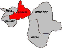
Babati District, Manyara
Babati District, Manyara | |
|---|---|
 Map of Manyara Region's Districts | |
| Country | |
| Region | Manyara |
Babati is a small city and district of the Manyara Region of Tanzania. The administrative capital of the district 'Babati Town' is located also administrative capital of the newly formed Manyara Region, 172 km south of Arusha. The District is the capital of Manyara Region. The district is bordered to the north by the Arusha Region, to the south east by the Simanjiro District, to the south by the Dodoma Region, to the south west by the Hanang District, and to the north west by the Mbulu District.
According to the 2002 Tanzania National Census, the population of the Babati District was 303,013.[1]
The District Commissioner of the Babati District is Hadija R.R. Nyembo.[2]
Wards
The Babati District is administratively divided into 21 wards:
| Arri | Babati | Bashnet |
| Bonga | Dabil | Dareda |
| Duru | Gallapo | Gidas |
| Kiru | Madunga | Magara |
| Magugu | Mamire | Mwada |
| Nkaiti | Qash | Riroda |
| Sigino | Singe | Ufana |
Cultural Tourism
Babati is home to Kahembe's Trekking and Cultural Safaris. Cultural tourism enables those interested in visiting rural areas to interact with the local people in their villages and homes. This interaction allows them to experience local foods while providing them the opportunity to join in ceremonies,dances and rituals.
Sources
- Babati District Homepage for the 2002 Tanzania National Census
- Tanzanian Government Directory Database
See also
- Districts of Tanzania
- Manyara Region
- Kiteto District
- Hanang District
- Simanjiro District
- Mbulu District
- KEFW Babati Link Group
References
