Ohio State Route 764
Appearance
 | ||||
| Route information | ||||
| Maintained by ODOT | ||||
| Length | 4.14 mi[1] (6.66 km) | |||
| Existed | 1947–present | |||
| Major junctions | ||||
| West end | ||||
| East end | ||||
| Location | ||||
| Country | United States | |||
| State | Ohio | |||
| Counties | Summit | |||
| Highway system | ||||
| ||||
| ||||
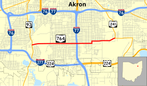
State Route 764 (SR 764) is an east–west state highway in the northeastern Ohio. Its western terminus is at State Route 93 and its eastern terminus is at State Route 241. The route lies entirely in Akron and is nearly 3½ miles from downtown, following Triplett Blvd. and Wilbeth Rd. It serves Akron Fulton International Airport and the Rubber Bowl.
Route description
All of SR 764 exists within the city limits of Akron in Summit County. There is no portion of SR 764 that is included as a component of the National Highway System, a network of highways identified as being most important for the economy, mobility and defense of the nation.[2]
This section needs expansion. You can help by adding to it. (February 2011) |
History
- 1947 – Original route certified; originally routed along its current routing.[3]
- 1950 – Extended to 2 miles (3.2 km) east of State Route 241.[3]
- 1970 – Truncated at State Route 241; former extension to 2 miles (3.2 km) east of State Route 241 decertified.[3]
- 1997 – From State Route 93 to 2 miles (3.2 km) east of State Route 93 and 1-mile (1.6 km) west of State Route 241 to State Route 241 upgraded to divided highway.[3]
- 2009 – Shortened at east end due to State Route 241 rerouting.[4]
Major intersections
The entire route is in Akron, Summit County.
| mi[1] | km | Destinations | Notes |
|---|---|---|---|
| 0.00 | 0.00 | Western terminus at signalized intersection. | |
| 2.16 | 3.48 | Diamond interchange. | |
| 4.14 | 6.66 | Eastern terminus at signalized intersection. | |
| 1.000 mi = 1.609 km; 1.000 km = 0.621 mi | |||
References
- ^ a b Ohio Department of Transportation. "Technical Services Straight Line Diagrams". Retrieved 2011-02-24.
- ^ National Highway System: Akron, Ohio (PDF) (Map). Federal Highway Administration. December 2003. Retrieved 2010-02-24.
- ^ a b c d Route 764 (The Unofficial Ohio State Highways Web Site) by John Simpson
- ^ "Straight-Line Diagrams County Update Table (Summit, 2009)". Ohio Department of Transportation.

