Monticchio
Monticchio | |
|---|---|
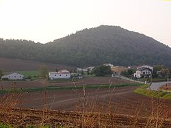
 View of Monticchio Sgarroni | |
 | |
| Country | Italy |
| Region | |
| Province | Potenza |
| Comune | Atella Rionero in Vulture |
| Elevation | 600 m (2,000 ft) |
| Population (2010) | |
• Total | 400 |
| Demonym | monticchiesi |
| Time zone | UTC+1 (CET) |
| • Summer (DST) | UTC+2 (CEST) |
| Postal code | 85028 |
| Dialing code | 0972 |
Monticchio is an Italian hamlet (frazione) belonging to the municipalities of Rionero in Vulture and Atella, in the Province of Potenza, Basilicata. The village is divided into 3 zones: Monticchio Laghi (part of Atella), Monticchio Bagni and Monticchio Sgarroni (both in Rionero).
History
First inhabited by the Normans, that occupied the ancient castle near Sgarroni (Castrum Monticuli),[1] it became, in the second half of 19th century, a strategic point for brigands after Italian unification. It was the shelter for some brigands as Carmine Crocco[2] and his subordinates Ninco Nanco (Giuseppe Summa), Giuseppe Caruso, Teodoro Gioseffi and Giovanni Fortunato. Nowadays it is a touristic place receptive for its natural environment and for mineral waters, due to the presence of some extinct volcanoes.
Geography
Monticchio is part of the Vulture region and lies near the borders with the Province of Avellino, Campania. The 3 tiny villages composing it are located in west of Mount Vulture and few km away from each other. A regional road links Monticchio Bagni and Monticchio Laghi.
- Monticchio Bagni[3] (M. Baths, 40°56′57.23″N 15°34′7.08″E / 40.9492306°N 15.5686333°E) is the northernmost locality, situated few km from the borders with Campania and from the closed railway station on the Avellino-Lioni-Rocchetta line. With a population of circa 250, it is the most populated locality.
- Monticchio Laghi[4] (M. Lakes, 40°56′6.83″N 15°36′31.08″E / 40.9352306°N 15.6086333°E) lies on the slopes of Mount Vulture and counts circa 150 inhabitants. In front of it there are situated two little volcanic lakes and the locality is receptive for tourism.[5] From 1971 the littler of the two lakes, habitat of the European Owl Moth, constitutes a natural reserve, named Riserva regionale Lago piccolo di Monticchio.[6] Around the village are situated two abbeys: St. Michael and the ruins of St. Hippolytus.
- Monticchio Sgarroni[3] (40°55′6.75″N 15°34′16.8″E / 40.9185417°N 15.571333°E), with a population of circa 50, is the lesser populated one. Also known as Sgarroni, close to it are located the ruins of a castle.
Monticchio dists 13 km from Melfi, 16 km from Rionero in Vulture, 22 from Atella, 68 from Potenza, 71 from Foggia and 123 from Avellino.
| Distances between the 3 zones | M. Bagni | M. Laghi | M. Sgarroni |
|---|---|---|---|
| Monticchio Bagni | •
|
6.0 km
|
5.5 km
|
| Monticchio Laghi | 6.0 km
|
•
|
5.6 km
|
| Monticchio Sgarroni | 5.5 km
|
5.6 km
|
•
|
Photogallery
-
The lakes of Monticchio
-
View of Monticchio Laghi
-
The abbey of St. Michael
-
Ruins of the abbey of St. Hippolytus
References
- ^ Raffaele Licinio: "Castelli medievali" , page 191 - Edizioni Dedalo, 1994. ISBN 88-220-6162-4
- ^ Template:It icon Biography of Carmine Crocco
- ^ a b Infos about Monticchio on Rionero website
- ^ Template:It icon Infos about Monticchio Laghi
- ^ Template:It icon An article about tourism in Monticchio Laghi
- ^ Template:It icon Infos about the Natural Reserve of Monticchio


