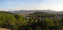
Carbonia, Sardinia
Carbonia | |
|---|---|
| Comune di Carbonia | |
 Carbonia's view | |
| Country | Italy |
| Region | Sardinia |
| Province | Carbonia-Iglesias (CI) |
| Frazioni | Bacu Abis, Barbusi, Cannas, Corongiu, Cortoghiana, Genna Corriga, Flumentepido, Is Gannaus, Is Meis, Medadeddu, Medau Desogus, Serbariu, Sirai, Sirri |
| Government | |
| • Mayor | Salvatore Cherchi |
| Area | |
• Total | 145.63 km2 (56.23 sq mi) |
| Elevation | 111 m (364 ft) |
| Population (March 31, 2008)[1] | |
• Total | 30,081 |
| • Density | 210/km2 (530/sq mi) |
| Demonym | Carboniesi or carboniensi |
| Time zone | UTC+1 (CET) |
| • Summer (DST) | UTC+2 (CEST) |
| Postal code | 09013 |
| Dialing code | 0781 |
| Patron saint | St. Pontian |
| Saint day | Third Thursday of May |
| Website | Official website |
Carbonia is a town and comune in the province of Carbonia-Iglesias, Sardinia, Italy. It is located is about an hour by car or train from Cagliari.

History
Carbonia was officially inaugurated on the 18 December 1938. Benito Mussolini ordered the building of the city and was present at its inauguration. The city was built in order to provide housing for the workforce of the nearby mines. The name Carbonia comes from the Italian word for coal, a resource that was abundant in this region.
The city has grown considerably since its birth in 1938, now boasting a population of over 30,000.
Since the mines' closing during the 1970s, Carbonia has had to deal with a high unemployment rate. Most Carbonians now find their employment in the heavy industry or transport sector.
Main sights
- Monte Sirai, a hill in the surroundings of the city that hosts the ruins of a Phoenician-Carthaginian built-up area
- Domus de janas in the surroundings of Sirri and Monte Crobu
- Romanesque church of Santa Maria di Flumentepido (11th century)
- Former Serbariu coal mine, now turned in a museum and in a site of industrial archaeology
External links
![]() Media related to Carbonia at Wikimedia Commons
Media related to Carbonia at Wikimedia Commons
- ^ "Popolazione Residente al 1° Gennaio 2018". Italian National Institute of Statistics. Retrieved 16 March 2019.


