Moselle Viaduct
Appearance
Moselle Viaduct Moseltalbrücke | |
|---|---|
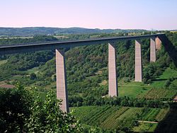
 The Moselle Viaduct seen from an observation site | |
| Coordinates | 50°18′53″N 7°29′40″E / 50.314722°N 7.494444°E |
| Carries | |
| Crosses | River Moselle |
| Locale | Winningen ↔ Dieblich, Germany |
| Characteristics | |
| Design | Beam bridge |
| Material | Steel |
| Total length | 935 metres (3,068 ft) |
| Width | 30.5 metres (100 ft) |
| Height | 136 metres (446 ft) |
| Longest span | 218.2 metres (716 ft) |
| No. of spans | 6 |
| History | |
| Constructed by | Heinz Schnorpfeil Bau GmbH DSD Dillinger Stahlbau Ed. Züblin AG Julius Berger Bauboag AG Lenz-Bau AG |
| Construction start | 1969 |
| Construction end | 1972 |
| Construction cost | 39 million DM |
| Location | |
 | |
The Moselle Viaduct (German: Moseltalbrücke) carries the Bundesautobahn 61 over the Moselle.
It is 935 meter long, 30.5 meter wide and stands 136 meter above the valley's lowest point.
Wikimedia Commons has media related to Moselle Viaduct.

