Salles-Lavalette
Appearance
From Wikipedia, the free encyclopedia
This is an old revision of this page, as edited by ArthurBot (talk | contribs) at 20:52, 10 April 2011 (r2.6.4) (robot Adding: ca:Salles-Lavalette). The present address (URL) is a permanent link to this revision, which may differ significantly from the current revision.
Revision as of 20:52, 10 April 2011 by ArthurBot (talk | contribs) (r2.6.4) (robot Adding: ca:Salles-Lavalette)
Place in Nouvelle-Aquitaine, France
Salles-Lavalette | |
|---|---|
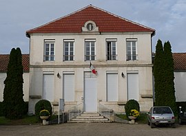
 Town hall | |
| Country | France |
| Region | Nouvelle-Aquitaine |
| Department | Charente |
| Arrondissement | Angoulême |
| Canton | Montmoreau-Saint-Cybard |
| Intercommunality | Montmorélien |
| Government | |
| • Mayor (2008–2014) | Éric Gendron |
Area 1 | 20.15 km2 (7.78 sq mi) |
| Population (2008) | 355 |
| • Density | 18/km2 (46/sq mi) |
| Time zone | UTC+01:00 (CET) |
| • Summer (DST) | UTC+02:00 (CEST) |
| INSEE/Postal code | 16362 /16190 |
| Elevation | 65–191 m (213–627 ft) (avg. 75 m or 246 ft) |
| 1 French Land Register data, which excludes lakes, ponds, glaciers > 1 km2 (0.386 sq mi or 247 acres) and river estuaries. | |
Salles-Lavalette is a commune in the Charente department in southwestern France.
Geography
The Lizonne forms the commune's eastern border.
See also
References
Hidden categories:
- Articles with short description
- Short description is different from Wikidata
- Pages using infobox settlement with image map1 but not image map
- Pages using infobox settlement with no coordinates
- Pages using infobox French commune with unknown parameters
- France articles requiring maintenance
- All stub articles
- Pages using the Kartographer extension

