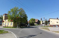
Marklowice Górne
Marklowice Górne | |
|---|---|
Village | |
 Village's centre | |
| Country | Poland |
| Voivodeship | Silesian |
| County | Cieszyn |
| Gmina | Zebrzydowice |
| First mentioned | 1305 |
| Government | |
| • Mayor | Tadeusz Guz |
Area | 4.64 km2 (1.79 sq mi) |
| Population | 920 |
| • Density | 200/km2 (510/sq mi) |
| Time zone | UTC+1 (CET) |
| • Summer (DST) | UTC+2 (CEST) |
| Car plates | SCI |
Marklowice Górne [marklɔˈvit͡sɛ ˈɡurnɛ] is a village in Gmina Zebrzydowice, Cieszyn County, Silesian Voivodeship, southern Poland. It has a population of about 920. Piotrówka River flows through the village.
Marklowice was a village in Cieszyn Silesia which split in the 17th century into the two parts, Marklowice Dolne and Marklowice Górne. They were joined together again at the end of the 19th century. After division of Cieszyn Silesia between Czechoslovakia and Poland in 1920, it was divided between these two countries. They were briefly reunited in the same country 1938-39 after Poland's annexation of Zaolzie, although as two separate gminas in two different powiats: Cieszyn (Marklowice Górne) and Frysztat (Marklowice Dolne). Today's Marklowice Górne is an eastern part of that village. Western part of the village is now known as Dolní Marklovice and lies in the Czech Republic.
Village was first mentioned in a written document in 1305.
See also
49°53′7.52″N 18°35′12.66″E / 49.8854222°N 18.5868500°E


