Waterford, Connecticut
Waterford, Connecticut | |
|---|---|
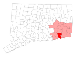
 Location in New London County, Connecticut | |
| Country | United States |
| State | Connecticut |
| NECTA | Norwich-New London |
| Region | Southeastern Connecticut |
| Incorporated | 1801 |
| Government | |
| • Type | Representative town meeting |
| • First selectman | Daniel M. Steward |
| • Town meeting moderator | Sharon M. Palmer |
| Area | |
• Total | 44.4 sq mi (115.0 km2) |
| • Land | 32.8 sq mi (85.0 km2) |
| • Water | 11.6 sq mi (30.1 km2) |
| Elevation | 46 ft (14 m) |
| Population (2005)[1] | |
• Total | 18,940 |
| • Density | 577/sq mi (223/km2) |
| Time zone | UTC-5 (Eastern) |
| • Summer (DST) | UTC-4 (Eastern) |
| ZIP code | 06375, 06385 |
| Area code | 860 |
| FIPS code | 09-80280 |
| GNIS feature ID | 0213526 |
| Website | http://www.waterfordct.org/ |
Waterford is a town in New London County, Connecticut, United States. It is named after Waterford, Ireland. The population was 19,152 at the 2000 census. The town center is listed as a census-designated place (CDP).
Geography
According to the United States Census Bureau, the town has a total area of 44.4 square miles (115.0 km²), of which, 32.8 square miles (84.8 km²) of it is land and 11.6 square miles (30.1 km²) of it (26.22%) is water. The town center CDP has a total area of 2.0 square miles (5.2 km²), all land.
Principal communities
- Graniteville
- Jordan
- Millstone
- Morningside Park
- Quaker Hill (06375)
- Bartlett Point, Best View, Cohanzie, Thames View
Other minor communities and geographic features are: Dufree Hill, East Neck, Fog Plain, Gilead, Goshen, Great Neck, Harrisons, Lake's Pond, Logger Hill, Mago Point, Magonk, Mullen Hill, Oswegatchie, Pepperbox Road, Pleasure Beach, Ridgewood Park, Riverside Beach, Spithead, Strand, West Neck.
Demographics
This town consists of a wide variety of rural and city living. Many residents live in apartments as well. As of the censusTemplate:GR of 2000, there were 19,152 people, 7,542 households, and 5,219 families residing in the town. The population density was 584.7 people per square mile (225.8/km²). There were 7,986 housing units at an average density of 243.8 per square mile (94.2/km²). The racial makeup of the town was 92.41% White, 2.22% African American, 0.48% Native American, 2.51% Asian, 0.02% Pacific Islander, 0.74% from other races, and 1.62% from two or more races. Hispanic or Latino of any race were 2.40% of the population.
There were 7,542 households out of which 28.2% had children under the age of 18 living with them, 56.6% were married couples living together, 8.7% had a female householder with no husband present, and 30.8% were non-families. 26.5% of all households were made up of individuals and 12.2% had someone living alone who was 65 years of age or older. The average household size was 2.41 and the average family size was 2.91.
In the town the population was spread out with 21.9% under the age of 18, 7.1% from 18 to 24, 26.6% from 25 to 44, 25.4% from 45 to 64, and 19.0% who were 65 years of age or older. The median age was 42 years. For every 100 females there were 92.1 males. For every 100 females age 18 and over, there were 88.7 males.
The median income for a household in the town was $56,047, and the median income for a family was $65,659. Males had a median income of $47,312 versus $32,046 for females. The per capita income for the town was $26,807. About 2.1% of families and 4.3% of the population were below the poverty line, including 4.7% of those under age 18 and 4.4% of those age 65 or over.
Town center
As of the census2 of 2000, there were 2,935 people, 1,298 households, and 759 families residing in the town center CDP. The population density was 1,465.7 inhabitants per square mile (566.6/km²). There were 1,379 housing units at an average density of 688.6 per square mile (266.2/km²). The racial makeup of the CDP was 91.65% White, 2.66% African American, 0.41% Native American, 2.28% Asian, 1.33% from other races, and 1.67% from two or more races. Hispanic or Latino of any race were 2.93% of the population.
There were 1,298 households out of which 23.0% had children under the age of 18 living with them, 43.5% were married couples living together, 10.9% had a female householder with no husband present, and 41.5% were non-families. 36.6% of all households were made up of individuals and 17.3% had someone living alone who was 65 years of age or older. The average household size was 2.19 and the average family size was 2.87.
In the CDP the population was spread out with 20.2% under the age of 18, 5.0% from 18 to 24, 28.9% from 25 to 44, 22.1% from 45 to 64, and 23.7% who were 65 years of age or older. The median age was 42 years. For every 100 females there were 88.1 males. For every 100 females age 18 and over, there were 84.3 males.
The median income for a household in the CDP was $42,409, and the median income for a family was $48,494. Males had a median income of $40,591 versus $29,015 for females. The per capita income for the CDP was $22,083. About 5.9% of families and 9.6% of the population were below the poverty line, including 19.3% of those under age 18 and 8.2% of those age 65 or over.
Notable residents
- Veronica Ballestrini, country music artist
- Martin Branner, cartoonist (Winnie Winkle)
- Billy Gardner, MLB player/manager
- Audrey Meadows, actress (The Honeymooners)
- Jesse Metcalfe, actor
Economy
Waterford's economic center is predominantly retail chains, including a variety of mini malls and the Crystal Mall. There are several family-owned delicatessens and restaurants. It is also home to Dominion's Millstone Nuclear Power Plant. It is a popular tourist area. Millstone consists of three reactors, the first built between 1966 and 1970. While Millstone's first reactor is no longer in operation, the remaining two still provide power to a variety of towns in New England.
Attractions
- The Connecticut College Arboretum is a 750-acre (3.0 km2) arboretum and botanical garden which lies partially within Quaker Hill Village, a district of Waterford.
- The Eugene O'Neill Theater Center is also located in Waterford. O'Neill was a famous playwright. The theater is now a historical location of Waterford.
- Waterford Beach
- Harkness Memorial State Park is a recreational area that provides a picturesque view of Long Island Sound. The park features the former mansion, gardens and grounds of Edward Harkness, who bought the property in 1907. Activities include fishing, formal gardening, golf, and tours of the mansion, known as Eolia. The Harkness estate is also open for formal occasions including weddings, and is often used for group photography.
- Adjacent to the Harkness Memorial State Park is Camp Harkness for the Handicapped, a summer facility for children and adults with physical and/or mental disabilities. Most of what is now Camp Harkness for the Handicapped was once a golf course, but there is no longer a trace of this golf course in evidence.
- The Waterford Speedbowl is a racetrack recognized under NASCAR’s Whelen All-American Series, and holds touring events throughout the year including the True Value Modified Series, International Super Modified Association, and North Eastern Midget Association. The track formerly held events sanctioned by the Whelen Modified Tour and the Busch East series. It is usually open every Saturday and includes events such as burnout contests and car shows.[2]
- As of September 2009, Waterford is the new home of the game show Deal or No Deal.
External links
References
- ^ U.S. Census Bureau Population Estimates
- ^ "History of the Track". Archived from the original on 2006-08-19. Retrieved 2006-11-07.


