Cayenne
farts
Cayenne | |
|---|---|
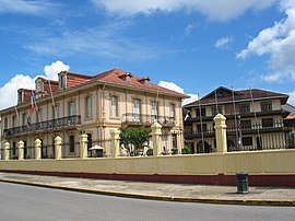
 Town hall | |
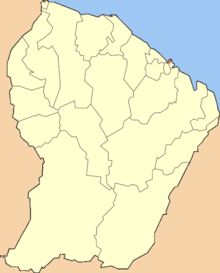
 Location of the commune (in red) within French Guiana | |
| Country | France |
| Overseas region and department | French Guiana |
| Arrondissement | Cayenne |
| Intercommunality | Centre Littoral |
| Government | |
| • Mayor | Rodolphe Alexandre |
Area 1 | 23.60 km2 (9.11 sq mi) |
| Population (2010) | 64,297 |
| • Density | 2,700/km2 (7,100/sq mi) |
| Time zone | UTC−03:00 |
| INSEE/Postal code | 97302 /97300 |
| 1 French Land Register data, which excludes lakes, ponds, glaciers > 1 km2 (0.386 sq mi or 247 acres) and river estuaries. | |
Cayenne (French pronunciation: [kajɛn]) is the capital of French Guiana, an overseas region and department of France located in South America. The city stands on a former island at the mouth of the Cayenne River on the Atlantic coast. The city's motto is "Ferit Aurum Industria" which means "Work brings wealth". Cayenne is the place from where most of the geosynchronous satellites are launched.[1]
At the 2006 census, there were 100,323 inhabitants in the urban area of Cayenne (as defined by INSEE), 50,594 of whom lived in the city (commune) of Cayenne proper, and the remainder in the neighbouring commune of Remire-Montjoly. The commune of Matoury (18,032 inhabitants in 1999), where Cayenne-Rochambeau Airport is located, is also a suburb of Cayenne, but it was not included in the official definition of the urban area by INSEE in 1999.
Geography
Cayenne is located on the banks of the estuary of the Cayenne River on the Atlantic Ocean. The city occupies part of the Ile de Cayenne. It is located 268 km from Saint-Laurent-du-Maroni and 64 km from Kourou.[2]
Distances to some cities:
- Paris: 7,100 km.
- Fort-de-France capital of Martinique: 1,500 kilometres (930 mi).[3]
- Paramaribo, capital of Suriname: 342 km to the northwest.
- Macapá, capital of the federal state of Amapá (Brazil): 554 km to the southeast.
History
Ignored by Spanish explorers, who found the region too hot and poor to be claimed, the region was not colonized until 1604, when a French settlement was founded. However, it was soon destroyed by the Portuguese, who were determined to enforce the provisions of the Treaty of Tordesillas. French colonists returned in 1643 and founded Cayenne, but were forced to leave once more following Amerindian attacks. In 1664, France finally succeeded at establishing a permanent settlement at Cayenne. Over the next decade the colony changed hands between the French, Dutch and English, before being restored to France. It was captured by an Anglo-Portuguese force at the invasion of Cayenne in 1809 and administered from Brazil until 1814, when it was returned to French control. It was used as a French penal colony from 1854 to 1938.

The city's population has recently grown dramatically, owing to high levels of immigration (chiefly from the West Indies and Brazil) as well as a high birthrate.
Economy
This section needs expansion. You can help by adding to it. (January 2012) |
Cayenne is an important industrial centre for the shrimp industry. The city formerly also contained sugar refineries.
Culture
Cayenne is very ethnically diverse, with Creole, Haitian, Brazilian, European, and Hmong and other Asian communities. It is famous for its annual carnival which starts with the arrival of Vaval (the Carnival King) on the first Sunday after New Year's Day and continues with very popular all-night costume balls and Sunday afternoon parades every weekend until Mardi Gras.
Main sights
Cayenne centres on its main commercial street, the Avenue Général de Gaulle. At the east end of the avenue near the coast is the Place des Palmistes and the Place de Grenoble (also known as the Place Léopold Héder). Most of the official buildings are located in this area: the Hôtel de Ville (the town hall) built by Jesuits in the 1890s, the Post Office, the Préfecture, residence of French Guiana's Préfect, and the Musée Départmental Franconie. To the west of this area lies Fort Cépérou, built in the 17th century, though now mostly in ruins. To the south lie the Place du Coq and Place Victor Schoelcher (named in honour of the anti-slavery activist) and a market.
To the south of this compact region is the Village Chinois (known as Chicago), separated from the rest of Cayenne by the Canal Laussat. It has a reputation for being a dangerous area.
Other buildings in the city include the Cathédrale Saint-Sauveur de Cayenne, municipal library, the municipal museum and a museum of French Guianese Culture (Musée des Cultures Guyanaise) and a scientific research institute (IRD or Institut de recherche pour le développement, formerly Orstom). The Jardin botanique de Cayenne is the city's botanical garden.
There are some beaches along the coast, like Montjoly and Montabo, and several promontories, though the waters contain sharks.
Transport
This section needs expansion. You can help by adding to it. (January 2012) |
Cayenne is served by the Cayenne-Rochambeau Airport, which is located in the neighbouring commune of Matoury.
Climate
Under the Köppen climate classification, Cayenne has a tropical monsoon climate. Average high and low temperatures are nearly identical throughout the course of the year averaging about 30 °C (86 °F) and 23 °C (73 °F) respectively. Cayenne sees a copious amount of precipitation during the year. The city features a very lengthy wet season and a very short dry season. The dry season only covers two months of the year (September and October) while the wet season covers the remainder of the year. Precipitation is seen even during the dry season, a trait commonly seen in places featuring tropical monsoon climates. Cayenne averages roughly 3,750 millimetres (150 in) of rain each year.
| Climate data for Cayenne | |||||||||||||
|---|---|---|---|---|---|---|---|---|---|---|---|---|---|
| Month | Jan | Feb | Mar | Apr | May | Jun | Jul | Aug | Sep | Oct | Nov | Dec | Year |
| Mean daily maximum °C (°F) | 29 (84) |
29 (84) |
29 (84) |
30 (86) |
29 (84) |
31 (88) |
31 (88) |
32 (90) |
32 (90) |
32 (90) |
31 (88) |
30 (86) |
30.4 (86.7) |
| Daily mean °C (°F) | 26 (79) |
26 (79) |
26 (79) |
27 (81) |
26 (79) |
27 (81) |
27 (81) |
28 (82) |
28 (82) |
28 (82) |
27 (81) |
27 (81) |
26.9 (80.4) |
| Mean daily minimum °C (°F) | 23 (73) |
23 (73) |
23 (73) |
24 (75) |
23 (73) |
23 (73) |
23 (73) |
23 (73) |
23 (73) |
23 (73) |
23 (73) |
23 (73) |
23.1 (73.6) |
| Average rainfall mm (inches) | 431 (17.0) |
423 (16.7) |
432 (17.0) |
480 (18.9) |
590 (23.2) |
457 (18.0) |
274 (10.8) |
144 (5.7) |
32 (1.3) |
42 (1.7) |
122 (4.8) |
317 (12.5) |
3,744 (147.6) |
| Average rainy days (≥ 0.1 mm) | 23 | 20 | 21 | 19 | 25 | 26 | 21 | 14 | 6 | 5 | 11 | 21 | 212 |
| Mean monthly sunshine hours | 142.6 | 116.0 | 136.4 | 129.0 | 136.4 | 171.0 | 207.7 | 232.5 | 261.0 | 266.6 | 234.0 | 192.2 | 2,225.4 |
| Source: climatetemp.info[4] | |||||||||||||
Administration

Cayenne is the chief town of six cantons:
- The first canton (North West) has 3,935 inhabitants;
- The second canton (North East) has 5,730 inhabitants;
- The third canton (South West) has 8,017 inhabitants;
- The fourth canton (Centre) has 5,955 inhabitants;
- The fifth canton (South) has 9,750 inhabitants;
- The sixth canton (South East) has 17,207 inhabitants
Cayenne in popular culture
The French folk song Cayenne (named after the main city of French Guiana) tells the story of a pimp who shoots a well-to-do client who grossly disrespected a prostitute, and is then convicted and transferred to the infamous penitentiary.[citation needed]
In The Hardy Boys #12: Footprints under the Window, the Hardys' investigations take them to Cayenne.
See also
{{{inline}}}
References
- ^ "page concernant le blason de la ville sur le site page de Redris". Pagesperso-orange.fr. Retrieved 13 March 2011.
- ^ Distances and duration of bonds in the dugout
- ^ Situation Géographique Préfecture de Guyane, archived September 15 2008 from the original
- ^ "Cayenne, French Guiana Weather Averages".
External links
- Préfecture de Guyane Official website

