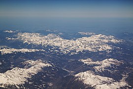
Berchtesgaden Alps
| Berchtesgaden Alps | |
|---|---|
 | |
| Highest point | |
| Peak | Hochkönig |
| Elevation | 2,941 m (9,649 ft) |
| Geography | |
Lua error in Module:Location_map at line 526: Unable to find the specified location map definition: "Module:Location map/data/Berchtesgardener Alpen.png" does not exist.
| |
| Countries | |
| States | Bavaria and Salzburg |
| Parent range | Northern Limestone Alps Northern Salzburg Alps |
The Berchtesgaden Alps (Template:Lang-de) are a mountain range of the Northern Limestone Alps, named after the market town of Berchtesgaden located in the centre. The central part belongs to the Berchtesgadener Land district of southeastern Bavaria, Germany, while the adjacent area in the north, east and south is part of the Austrian state of Salzburg (Salzburgerland).
Geography
The range is bounded by the Saalach river in the west and the Salzach in the east. Its northernmost peak is the Untersberg south of Salzburg. Surrounding ranges are:

- the Salzkammergut Mountains to the east
- the Tennengebirge to the southeast
- the Salzburg Slate Alps to the south
- the Kitzbühel Alps to the southwest
- the Loferer and Leoganger Steinberge to the west
- the Chiemgau Alps to the northwest
Mountains and lakes
While the highest mountain of the Berchtesgaden Alps is the Hochkönig (2,941 metres (9,649 ft)) located in the Austrian part, the best known peak is the Watzmann massif, the third-highest mountain of Germany at 2,713 metres (8,901 ft). The range also comprises the Obersalzberg slope east of Berchtesgaden, notorious for the former Berghof domicile of Adolf Hitler. The picturesque heart is the glacial Königssee lake with the famous St. Bartholomew's pilgrimage church, part of the Berchtesgaden National Park established in 1978. The range also comprises glaciers like the Blaueis as well as the Steinernes Meer high karst plateau.
Other major peaks include: Template:Multicol
- Hochkalter, 2,607 m.
- Großer Hundstod, 2,593 m.
- Funtenseetauern, 2,578 m.
- Hocheisspitze, 2,523 m.
- Hoher Göll, 2,522 m.
- Großes Teufelshorn, 2,361 m.
- Kahlersberg, 2,350 m.
- Stadelhorn, 2,286 m.
Literature
- Heinrich Bauregger: Berchtesgadener Land, Rother Wanderführer, Bergverlag Rother, Munich, ISBN 978-3-7633-4226-6
- Bernhard Kühnhauser: Berchtesgadener Alpen, Rother Alpenvereinsführer alpin, Bergverlag Rother, Munich, ISBN 978-3-7633-1127-9 appeared in October 8
References

