Villa General Mitre
Appearance
Villa General Mitre | |
|---|---|
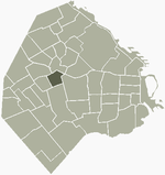
 Location of Villa General Mitre within Buenos Aires | |
| Country | |
| Autonomous City | Buenos Aires |
| Comuna | C11 |
| Area | |
• Total | 2.2 km2 (0.8 sq mi) |
| Population | |
• Total | 36,000 |
| • Density | 16,000/km2 (42,000/sq mi) |
| Time zone | UTC-3 (ART) |
Villa General Mitre is a neighbourhood, or barrio of Buenos Aires.
It has an area of 2.2 square kilometres, and a population of 36,000.
