Semide
You can help expand this article with text translated from the corresponding article in French. (December 2008) Click [show] for important translation instructions.
|
Semide | |
|---|---|
 | |
| Country | France |
| Region | Grand Est |
| Department | Ardennes |
| Arrondissement | Vouziers |
| Canton | Machault |
| Intercommunality | Argonne Ardennaise |
| Government | |
| • Mayor (2008–2014) | Jean-Marc Lampson |
Area 1 | 37.04 km2 (14.30 sq mi) |
| Population (2008) | 213 |
| • Density | 5.8/km2 (15/sq mi) |
| Time zone | UTC+01:00 (CET) |
| • Summer (DST) | UTC+02:00 (CEST) |
| INSEE/Postal code | 08410 /08400 |
| Elevation | 110–204 m (361–669 ft) (avg. 149 m or 489 ft) |
| 1 French Land Register data, which excludes lakes, ponds, glaciers > 1 km2 (0.386 sq mi or 247 acres) and river estuaries. | |
Semide is a commune in the Ardennes department in the Champagne-Ardenne region in northern of France.
It is located 200 km (120 mi) northeast of Paris, 40 km (25 mi) of Reims).
History
Semide has not always been what it is today. Formerly, the chalky soil gave bad harvest. This poor land, where resinous had been plant under the Second Empire provided to the sheep kine sparse grass. In the 1960s, Semide underwent a change which has modified its economy, its way of life and the landscape. Mecanisation, motorisation, clearing, fertilizer utilization and regrouping of lands mark out the intensive farming beginning dominates by cereals.
Population
The inhabitants are called Semidas.
| Year | Pop. | ±% |
|---|---|---|
| 1962 | 314 | — |
| 1968 | 293 | −6.7% |
| 1975 | 251 | −14.3% |
| 1982 | 264 | +5.2% |
| 1990 | 258 | −2.3% |
| 1999 | 245 | −5.0% |
| 2008 | 213 | −13.1% |
Sights
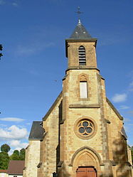
- St-Pierre St-Paul Church from the twelfth century.
- Big Bertha : Vestige of an installation of a Langer Max (officially called 38 cm SKL/45), wrongly called by usage Big Bertha.
- National graveyard from the First World War.
Economy
Semide main's activity is farming, predominantly cereal and sugar beet production.


