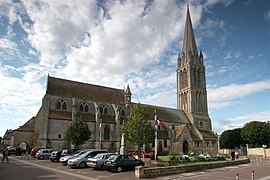
Bernières-sur-Mer
Appearance
You can help expand this article with text translated from the corresponding article in French. (December 2008) Click [show] for important translation instructions.
|
Bernières-sur-Mer | |
|---|---|
 Notre Dame | |
| Country | France |
| Region | Normandy |
| Department | Calvados |
| Arrondissement | Caen |
| Canton | Douvres-la-Délivrande |
| Government | |
| • Mayor (2008–2014) | Maryvonne Mottin |
Area 1 | 7.66 km2 (2.96 sq mi) |
| Population (2008) | 2,371 |
| • Density | 310/km2 (800/sq mi) |
| Time zone | UTC+01:00 (CET) |
| • Summer (DST) | UTC+02:00 (CEST) |
| INSEE/Postal code | 14066 /14990 |
| Elevation | 0–55 m (0–180 ft) (avg. 4 m or 13 ft) |
| 1 French Land Register data, which excludes lakes, ponds, glaciers > 1 km2 (0.386 sq mi or 247 acres) and river estuaries. | |
Bernières-sur-Mer is a commune in the Calvados department in the Basse-Normandie region in northwestern France. The town was liberated by The Queen's Own Rifles of Canada on the 6th of June, 1944 as part of the leading assault wave of D-Day Operation Overlord which began the liberation of France in World War II.
Latter, Le Régiment de la Chaudière, a French Canadian infantry unit, came ashore at Bernières-sur-Mer after the D-Day landings.
Population
| Year | Pop. | ±% |
|---|---|---|
| 1793 | 1,245 | — |
| 1800 | 1,288 | +3.5% |
| 1806 | 1,403 | +8.9% |
| 1821 | 1,443 | +2.9% |
| 1831 | 1,482 | +2.7% |
| 1836 | 1,460 | −1.5% |
| 1841 | 1,368 | −6.3% |
| 1846 | 1,414 | +3.4% |
| 1851 | 1,378 | −2.5% |
| 1856 | 1,301 | −5.6% |
| 1861 | 1,198 | −7.9% |
| 1866 | 1,235 | +3.1% |
| 1872 | 1,130 | −8.5% |
| 1876 | 1,078 | −4.6% |
| 1881 | 966 | −10.4% |
| 1886 | 916 | −5.2% |
| 1891 | 836 | −8.7% |
| 1896 | 807 | −3.5% |
| 1901 | 864 | +7.1% |
| 1906 | 876 | +1.4% |
| 1911 | 820 | −6.4% |
| 1921 | 812 | −1.0% |
| 1926 | 740 | −8.9% |
| 1931 | 815 | +10.1% |
| 1936 | 803 | −1.5% |
| 1946 | 981 | +22.2% |
| 1954 | 1,065 | +8.6% |
| 1962 | 930 | −12.7% |
| 1968 | 964 | +3.7% |
| 1975 | 1,053 | +9.2% |
| 1982 | 1,548 | +47.0% |
| 1990 | 1,563 | +1.0% |
| 1999 | 1,882 | +20.4% |
| 2008 | 2,371 | +26.0% |
Twin towns
- Eisingen, Bavaria, Germany since 1994.
See also
References
External links
Wikimedia Commons has media related to Bernières-sur-Mer.


